
 Bel-Ha
San Jose El Alto
El Porvenir
Nueva Palestina
Santa Lucía
Chemax
La Morita
Temoac
Zacualpan
Bel-Ha
San Jose El Alto
El Porvenir
Nueva Palestina
Santa Lucía
Chemax
La Morita
Temoac
Zacualpan
Splash Tangamanga on the map, San Luis Potosi, Mexico
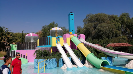
Photo
Where is located Splash Tangamanga
Splash Tangamanga — local attraction, which is located at Av. Salvador Nava 3055, Tangamanga, 78269 San Luis, S.L.P., Mexico and belongs to the category — water park. Average visitor rating for this place — 3.9 (according to 621 rating, information from open sources and relevant for 2022).
Exact location — Splash Tangamanga, marked on the map with a red marker.
You can get directions to Splash Tangamanga on the map from your location.
What else is interesting in San Luis Potosi? You can see all the sights if you go to the city page.
Coordinates
Splash Tangamanga, Mexico coordinates in decimal format: latitude — 22.120891911726467, longitude — -101.00239429281429. When converted to degrees, minutes, seconds Splash Tangamanga has the following coordinates: 22°7′15.21 north latitude and -101°0′8.62 east longitude.
Nearby cities
The largest cities that are located nearby:
- Soledad de Graciano Sánchez — 6 km
- León — 135 km
- Aguascalientes — 137 km
- Irapuato — 168 km
- Zacatecas — 176 km
- Salamanca — 177 km
- Celaya — 181 km
- Santiago de Querétaro — 184 km
- San Juan del Río — 222 km
- Fresnillo — 222 km
- Ciudad Victoria — 256 km
- Morelia — 272 km
- Zamora — 275 km
- Tonalá — 288 km
- Tlaquepaque — 293 km
- Guadalajara — 295 km
- Tantoyuca — 298 km
- Zapopan — 300 km
- Tampico — 320 km
Distance to the capital
Distance to the capital (Mexico City) is about — 357 km.