
 Bel-Ha
San Jose El Alto
El Porvenir
Nueva Palestina
Santa Lucía
Chemax
La Morita
Temoac
Zacualpan
Bel-Ha
San Jose El Alto
El Porvenir
Nueva Palestina
Santa Lucía
Chemax
La Morita
Temoac
Zacualpan
Plaza de las Tres Centurias on the map, Aguascalientes, Mexico
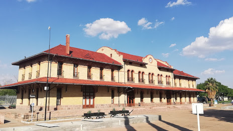
Photo
Where is located Plaza de las Tres Centurias
Plaza de las Tres Centurias — local attraction, which is located at Alameda 301, Barrio de la Estación, 20259 Aguascalientes, Ags., Mexico and belongs to the category — theme park. Average visitor rating for this place — 4.7 (according to 9771 rating, information from open sources and relevant for 2022).
Exact location — Plaza de las Tres Centurias, marked on the map with a red marker.
You can get directions to Plaza de las Tres Centurias on the map from your location.
What else is interesting in Aguascalientes? You can see all the sights if you go to the city page.
Coordinates
Plaza de las Tres Centurias, Mexico coordinates in decimal format: latitude — 21.884730395875117, longitude — -102.28109949281844. When converted to degrees, minutes, seconds Plaza de las Tres Centurias has the following coordinates: 21°53′5.03 north latitude and -102°16′51.96 east longitude.
Nearby cities
The largest cities that are located nearby:
- Zacatecas — 102 km
- León — 105 km
- San Luis Potosi — 137 km
- Soledad de Graciano Sánchez — 142 km
- Fresnillo — 154 km
- Irapuato — 165 km
- Tonalá — 171 km
- Tlaquepaque — 173 km
- Guadalajara — 174 km
- Zapopan — 178 km
- Salamanca — 184 km
- Zamora — 210 km
- Celaya — 215 km
- Santiago de Querétaro — 244 km
- Morelia — 267 km
- Tepic — 271 km
- Uruapan — 275 km
- San Juan del Río — 291 km
- Colima — 328 km
Distance to the capital
Distance to the capital (Mexico City) is about — 426 km.