
 Litoral Del Bajo San Juan
El Cantón de San Pablo
Juan Frío
Santa Barbara
El Juncal
Dibulla
Vereda Campo Alegre
San Pablo
Guaramito
Litoral Del Bajo San Juan
El Cantón de San Pablo
Juan Frío
Santa Barbara
El Juncal
Dibulla
Vereda Campo Alegre
San Pablo
Guaramito
Estación Metrocable Arví on the map, Medellín, Colombia
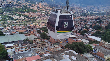
Photo
Where is located Estación Metrocable Arví
Estación Metrocable Arví — local attraction, which is located at Santa Elena, Medellin, Antioquia, Colombia and belongs to the category — mountain cable car. Average visitor rating for this place — 4.8 (according to 2154 ratings, information from open sources and relevant for 2022).
Exact location — Estación Metrocable Arví, marked on the map with a red marker.
You can get directions to Estación Metrocable Arví on the map from your location.
What else is interesting in Medellín? You can see all the sights if you go to the city page.
Coordinates
Estación Metrocable Arví, Colombia coordinates in decimal format: latitude — 6.28169774452248, longitude — -75.50293859299641. When converted to degrees, minutes, seconds Estación Metrocable Arví has the following coordinates: 6°16′54.11 north latitude and -75°30′10.58 east longitude.
Nearby cities
The largest cities that are located nearby:
- Bello — 7 km
- Envigado — 11 km
- Itagüi — 12 km
- Manizales — 133 km
- Dos Quebradas — 159 km
- Pereira — 162 km
- Cartago — 172 km
- Armenia — 193 km
- Ibagué — 206 km
- Barrancabermeja — 208 km
- Girardot — 234 km
- Soacha — 239 km
- Tuluá — 251 km
- Tunja — 258 km
- Buga — 274 km
- Monteria — 276 km
- Giron — 278 km
- Bucaramanga — 285 km
- Floridablanca — 286 km
Distance to the capital
Distance to the capital (Bogota) is about — 245 km.