
 Belém
Maranguape
Paranaguá
Paranaguá
Monte Alegre
Alvorada de Minas
Bragança
Laguna
Ibiporã
Belém
Maranguape
Paranaguá
Paranaguá
Monte Alegre
Alvorada de Minas
Bragança
Laguna
Ibiporã
Praça do Ferreira - Centro on the map, Fortaleza, Brazil
Photo
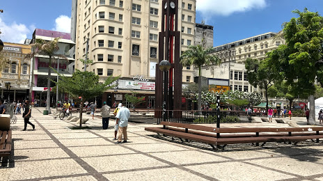
Where is located Praça do Ferreira - Centro
Praça do Ferreira - Centro — local attraction, which is located at R. Floriano Peixoto - Centro, Fortaleza - CE, 60025-060, Brazil and belongs to the category — plaza. Average visitor rating for this place — 4.1 (according to 20866 ratings, information from open sources and relevant for 2022).
Exact location — Praça do Ferreira - Centro, marked on the map with a red marker.
You can get directions to Praça do Ferreira - Centro on the map from your location.
What else is interesting in Fortaleza? You can see all the sights if you go to the city page.
Coordinates
Praça do Ferreira - Centro, Brazil coordinates in decimal format: latitude — -3.7283753082010125, longitude — -38.52868477285793. When converted to degrees, minutes, seconds Praça do Ferreira - Centro has the following coordinates: -3°43′42.15 north latitude and -38°31′43.27 east longitude.
Nearby cities
The largest cities that are located nearby:
- Caucaia — 15 km
- Maracanaú — 19 km
- Mossoro — 206 km
- Parnaíba — 370 km
- Juazeiro do Norte — 396 km
- Natal — 430 km
- Parnamirim — 432 km
- Campina Grande — 483 km
- Teresina — 494 km
- Timon — 498 km
- Santa Rita — 542 km
- Caxias — 547 km
- João Pessoa — 551 km
- Caruaru — 576 km
- Camaragibe — 613 km
- Recife — 623 km
- Jaboatão dos Guararapes — 625 km
- São Luís — 649 km
- Petrolina — 662 km