
 Puerto de la Duquesa
La Serna de Iguña
Pumalverde
Puentenansa
La Iglesia
Casar de Periedo
Fuengirola
Renedo de Piélagos
Villabanez
Puerto de la Duquesa
La Serna de Iguña
Pumalverde
Puentenansa
La Iglesia
Casar de Periedo
Fuengirola
Renedo de Piélagos
Villabanez
Parque Huerta Otea on the map, Salamanca, Spain
Photo
Where is located Parque Huerta Otea
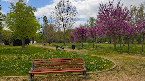
Parque Huerta Otea — local attraction, which is located at C. Manuel Ramos Andrade, 8, 37007 Salamanca, Spain and belongs to the category — park. Average visitor rating for this place — 4.3 (according to 619 ratings, information from open sources and relevant for 2022).
Exact location — Parque Huerta Otea, marked on the map with a red marker.
You can get directions to Parque Huerta Otea on the map from your location.
What else is interesting in Salamanca? You can see all the sights if you go to the city page.
Coordinates
Parque Huerta Otea, Spain coordinates in decimal format: latitude — 40.96458446879852, longitude — -5.682406792353089. When converted to degrees, minutes, seconds Parque Huerta Otea has the following coordinates: 40°57′52.5 north latitude and -5°40′56.66 east longitude.
Nearby cities
The largest cities that are located nearby:
- Valladolid — 108 km
- Móstoles — 167 km
- Alcorcón — 169 km
- Fuenlabrada — 174 km
- Leganés — 175 km
- Alcobendas — 177 km
- Getafe — 179 km
- León — 180 km
- Torrejón de Ardoz — 193 km
- Alcala de Henares — 201 km
- Burgos — 221 km
- Ourense — 235 km
- Braga
 (Portugal) — 237 km
 - Coimbra (Portugal) — 247 km
- Porto (Portugal) — 248 km
- Badajoz — 257 km
- Oviedo — 265 km
- Gijón — 283 km
- Vigo — 287 km
Distance to the capital
Distance to the capital (Madrid) is about — 178 km.