
 Puerto de la Duquesa
La Serna de Iguña
Pumalverde
Puentenansa
La Iglesia
Casar de Periedo
Fuengirola
Renedo de Piélagos
Villabanez
Puerto de la Duquesa
La Serna de Iguña
Pumalverde
Puentenansa
La Iglesia
Casar de Periedo
Fuengirola
Renedo de Piélagos
Villabanez
Parque de Brandía on the map, Santiago de Compostela, Spain
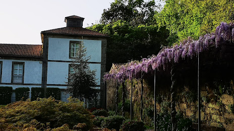
Photo
Where is located Parque de Brandía
Parque de Brandía — local attraction, which is located at Unnamed Road,15897, 15897 Santiago de Compostela, A Coruña, Spain and belongs to the category — park. Average visitor rating for this place — 4.7 (according to 39 ratings, information from open sources and relevant for 2022).
Exact location — Parque de Brandía, marked on the map with a red marker.
You can get directions to Parque de Brandía on the map from your location.
What else is interesting in Santiago de Compostela? You can see all the sights if you go to the city page.
Coordinates
Parque de Brandía, Spain coordinates in decimal format: latitude — 42.86948493663302, longitude — -8.579824592293308. When converted to degrees, minutes, seconds Parque de Brandía has the following coordinates: 42°52′10.15 north latitude and -8°34′47.37 east longitude.
Nearby cities
The largest cities that are located nearby:
- A Coruña — 55 km
- Vigo — 72 km
- Ourense — 82 km
- Braga
 (Portugal) — 148 km
 - Porto (Portugal) — 190 km
- Oviedo — 223 km
- Gijón — 242 km
- León — 244 km
- Coimbra (Portugal) — 296 km
- Salamanca — 320 km
- Valladolid — 343 km
- Santander — 385 km
- Burgos — 401 km
- Bilbao — 454 km
- Amadora (Portugal) — 459 km
- Queluz (Portugal) — 460 km
- Lisbon (Portugal) — 462 km
- Badajoz — 462 km
- Vitoria-Gasteiz — 475 km
Distance to the capital
Distance to the capital (Madrid) is about — 488 km.