
 Bel-Ha
San Jose El Alto
El Porvenir
Nueva Palestina
Santa Lucía
Chemax
La Morita
Temoac
Zacualpan
Bel-Ha
San Jose El Alto
El Porvenir
Nueva Palestina
Santa Lucía
Chemax
La Morita
Temoac
Zacualpan
Ex-convento del Carmen on the map, Morelia, Mexico
Photo
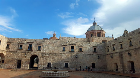
Where is located Ex-convento del Carmen
Ex-convento del Carmen — local attraction, which is located at 3ra. Priv. de Mártires de Tacubaya 59, Centro histórico de Morelia, 58000 Morelia, Mich., Mexico and belongs to the category — place of worship. Average visitor rating for this place — 4.3 (according to 20 ratings, information from open sources and relevant for 2022).
Exact location — Ex-convento del Carmen, marked on the map with a red marker.
You can get directions to Ex-convento del Carmen on the map from your location.
What else is interesting in Morelia? You can see all the sights if you go to the city page.
Coordinates
Ex-convento del Carmen, Mexico coordinates in decimal format: latitude — 19.7062856833423, longitude — -101.19195129285478. When converted to degrees, minutes, seconds Ex-convento del Carmen has the following coordinates: 19°42′22.63 north latitude and -101°11′31.02 east longitude.
Nearby cities
The largest cities that are located nearby:
- Uruapan — 94 km
- Salamanca — 95 km
- Celaya — 99 km
- Irapuato — 109 km
- Zamora — 117 km
- Santiago de Querétaro — 128 km
- San Juan del Río — 146 km
- León — 165 km
- Toluca — 167 km
- Metepec — 174 km
- Ciudad López Mateos — 201 km
- Cuautitlán Izcalli — 203 km
- Naucalpan — 206 km
- Tlalnepantla — 210 km
- Buenavista — 211 km
- Coacalco — 218 km
- Ecatepec — 224 km
- Cuernavaca — 224 km
- Ojo de Agua — 225 km
Distance to the capital
Distance to the capital (Mexico City) is about — 218 km.