
 Bel-Ha
San Jose El Alto
El Porvenir
Nueva Palestina
Santa Lucía
Chemax
La Morita
Temoac
Zacualpan
Bel-Ha
San Jose El Alto
El Porvenir
Nueva Palestina
Santa Lucía
Chemax
La Morita
Temoac
Zacualpan
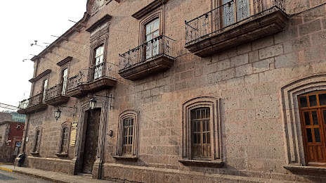
Palacio Municipal de Morelia on the map, Morelia, Mexico
Photo
Where is located Palacio Municipal de Morelia
Palacio Municipal de Morelia — local attraction, which is located at 58000, Allende 403, Centro histórico de Morelia, 58000 Morelia, Mich., Mexico and belongs to the category — palace. Average visitor rating for this place — 4.4 (according to 121 rating, information from open sources and relevant for 2022).
Exact location — Palacio Municipal de Morelia, marked on the map with a red marker.
You can get directions to Palacio Municipal de Morelia on the map from your location.
What else is interesting in Morelia? You can see all the sights if you go to the city page.
Coordinates
Palacio Municipal de Morelia, Mexico coordinates in decimal format: latitude — 19.70171158132338, longitude — -101.19545839285493. When converted to degrees, minutes, seconds Palacio Municipal de Morelia has the following coordinates: 19°42′6.16 north latitude and -101°11′43.65 east longitude.
Nearby cities
The largest cities that are located nearby:
- Uruapan — 94 km
- Salamanca — 95 km
- Celaya — 99 km
- Irapuato — 109 km
- Zamora — 117 km
- Santiago de Querétaro — 128 km
- San Juan del Río — 146 km
- León — 165 km
- Toluca — 167 km
- Metepec — 174 km
- Ciudad López Mateos — 201 km
- Cuautitlán Izcalli — 203 km
- Naucalpan — 206 km
- Tlalnepantla — 210 km
- Buenavista — 211 km
- Coacalco — 218 km
- Ecatepec — 224 km
- Cuernavaca — 224 km
- Ojo de Agua — 225 km
Distance to the capital
Distance to the capital (Mexico City) is about — 218 km.