
 Gilserberg
Berlin
Bordesholm
Bechtolsheim
Aub
Triptis
Heppenheim
Biblis
Angermünde
Gilserberg
Berlin
Bordesholm
Bechtolsheim
Aub
Triptis
Heppenheim
Biblis
Angermünde
Donaustauf Castle on the map, Regensburg, Germany
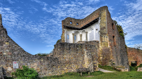
Photo
Where is located Donaustauf Castle
Donaustauf Castle — local attraction, which is located at Burgstraße, 93093 Donaustauf, Germany and belongs to the category — historical landmark. Average visitor rating for this place — 4.7 (according to 901 rating, information from open sources and relevant for 2022).
Exact location — Donaustauf Castle, marked on the map with a red marker.
You can get directions to Donaustauf Castle on the map from your location.
What else is interesting in Regensburg? You can see all the sights if you go to the city page.
Coordinates
Donaustauf Castle, Germany coordinates in decimal format: latitude — 49.03014233790679, longitude — 12.207034107914632. When converted to degrees, minutes, seconds Donaustauf Castle has the following coordinates: 49°1′48.51 north latitude and 12°12′25.32 east longitude.
Nearby cities
The largest cities that are located nearby:
- Ingolstadt — 56 km
- Nuremberg — 88 km
- Fürth — 95 km
- Erlangen — 101 km
- Munich — 104 km
- Augsburg — 113 km
- Pilsen
 (Czech Republic) — 121 km
 - Salzburg
 (Austria) — 151 km
 - Ulm — 169 km
- Würzburg — 176 km
- Linz (Austria) — 179 km
- Innsbruck (Austria) — 200 km
- Prague (Czech Republic) — 203 km
- Gera — 207 km
- Chemnitz — 209 km
- Heilbronn — 210 km
- Stuttgart — 214 km
- Reutlingen — 220 km
- Erfurt — 230 km
Distance to the capital
Distance to the capital (Berlin) is about — 397 km.