
 Józefów nad Wisłą
Gorzyce Wielkie
Rogówek
Sromowce Niżne
Wyszków County
Kruszewo
Jantar
Sady Górne
Nagoszewo
Józefów nad Wisłą
Gorzyce Wielkie
Rogówek
Sromowce Niżne
Wyszków County
Kruszewo
Jantar
Sady Górne
Nagoszewo
Roman Catholic Parish of St. Michael the Archangel on the map, Gorlice, Poland
Photo
Where is located Roman Catholic Parish of St. Michael the Archangel
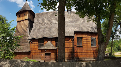
Roman Catholic Parish of St. Michael the Archangel — local attraction, which is located at Binarowa 409, 38-340 Binarowa, Poland and belongs to the category — religious institution. Average visitor rating for this place — 4.8 (according to 114 ratings, information from open sources and relevant for 2022).
Exact location — Roman Catholic Parish of St. Michael the Archangel, marked on the map with a red marker.
You can get directions to Roman Catholic Parish of St. Michael the Archangel on the map from your location.
What else is interesting in Gorlice? You can see all the sights if you go to the city page.
Coordinates
Roman Catholic Parish of St. Michael the Archangel, Poland coordinates in decimal format: latitude — 49.65630006061635, longitude — 21.155967907937015. When converted to degrees, minutes, seconds Roman Catholic Parish of St. Michael the Archangel has the following coordinates: 49°39′22.68 north latitude and 21°9′21.48 east longitude.
Nearby cities
The largest cities that are located nearby:
- Tarnow — 41 km
- Rzeszow — 73 km
- Kraków — 97 km
- Košice
 (Slovakia) — 103 km
 - Kielce — 139 km
- Uzhhorod
 (Ukraine) — 141 km
 - Bielsko-Biala — 151 km
- Dabrowa Gornicza — 157 km
- Sosnowiec — 161 km
- Katowice — 165 km
- Chorzow — 171 km
- Miskolc
 (Hungary) — 175 km
 - Ruda Slaska — 176 km
- Bytom — 176 km
- Zabrze — 183 km
- Gliwice — 189 km
- Częstochowa — 191 km
- Rybnik — 192 km
- Nyíregyháza (Hungary) — 193 km
Distance to the capital
Distance to the capital (Warsaw) is about — 286 km.