
 Gilserberg
Berlin
Bordesholm
Bechtolsheim
Aub
Triptis
Heppenheim
Biblis
Angermünde
Gilserberg
Berlin
Bordesholm
Bechtolsheim
Aub
Triptis
Heppenheim
Biblis
Angermünde
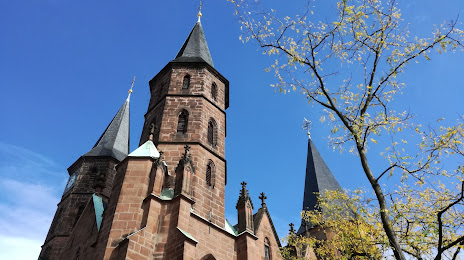
Stiftskirche - Prot. Stiftskirchengemeinde Kaiserslautern on the map, Kaiserslautern, Germany
Photo
Where is located Stiftskirche - Prot. Stiftskirchengemeinde Kaiserslautern
Stiftskirche - Prot. Stiftskirchengemeinde Kaiserslautern — local attraction, which is located at Marktstraße 13, 67655 Kaiserslautern, Germany and belongs to the category — evangelical church. Average visitor rating for this place — 4.3 (according to 195 ratings, information from open sources and relevant for 2022).
Exact location — Stiftskirche - Prot. Stiftskirchengemeinde Kaiserslautern, marked on the map with a red marker.
You can get directions to Stiftskirche - Prot. Stiftskirchengemeinde Kaiserslautern on the map from your location.
What else is interesting in Kaiserslautern? You can see all the sights if you go to the city page.
Coordinates
Stiftskirche - Prot. Stiftskirchengemeinde Kaiserslautern, Germany coordinates in decimal format: latitude — 49.44404024887, longitude — 7.7710537079293704. When converted to degrees, minutes, seconds Stiftskirche - Prot. Stiftskirchengemeinde Kaiserslautern has the following coordinates: 49°26′38.54 north latitude and 7°46′15.79 east longitude.
Nearby cities
The largest cities that are located nearby:
- Ludwigshafen — 50 km
- Mannheim — 52 km
- Saarbrücken — 59 km
- Heidelberg — 67 km
- Karlsruhe — 67 km
- Mainz — 71 km
- Wiesbaden — 79 km
- Darmstadt — 80 km
- Trier — 87 km
- Pforzheim — 92 km
- Strasbourg
 (France) — 96 km
 - Frankfurt — 99 km
- Koblenz — 102 km
- Offenbach — 103 km
- Heilbronn — 111 km
- Metz (France) — 119 km
- Stuttgart — 128 km
- Nancy (France) — 141 km
- Reutlingen — 148 km
Distance to the capital
Distance to the capital (Berlin) is about — 522 km.