
 Bel-Ha
San Jose El Alto
El Porvenir
Nueva Palestina
Santa Lucía
Chemax
La Morita
Temoac
Zacualpan
Bel-Ha
San Jose El Alto
El Porvenir
Nueva Palestina
Santa Lucía
Chemax
La Morita
Temoac
Zacualpan
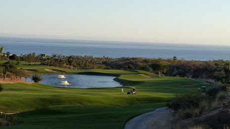
Cabo Real Golf Club on the map, San José del Cabo, Mexico
Photo
Where is located Cabo Real Golf Club
Cabo Real Golf Club — local attraction, which is located at km 19.5, México 1, Zona del interior, 23405 San José del Cabo, B.C.S., Mexico and belongs to the category — golf course. Average visitor rating for this place — 4.6 (according to 249 ratings, information from open sources and relevant for 2022).
Exact location — Cabo Real Golf Club, marked on the map with a red marker.
You can get directions to Cabo Real Golf Club on the map from your location.
What else is interesting in San José del Cabo? You can see all the sights if you go to the city page.
Coordinates
Cabo Real Golf Club, Mexico coordinates in decimal format: latitude — 22.99198104926153, longitude — -109.76781409279853. When converted to degrees, minutes, seconds Cabo Real Golf Club has the following coordinates: 22°59′31.13 north latitude and -109°46′4.13 east longitude.
Nearby cities
The largest cities that are located nearby:
- La Paz — 134 km
- Los Mochis — 310 km
- Mazatlán — 335 km
- Navojoa — 444 km
- Ciudad Obregón — 489 km
- Durango — 521 km
- Tepic — 524 km
- Puerto Vallarta — 534 km
- Guaymas — 549 km
- Hermosillo — 675 km
- Gómez Palacio — 680 km
- Torreón — 685 km
- Fresnillo — 695 km
- Delicias — 701 km
- Matamoros — 701 km
- Zapopan — 702 km
- Guadalajara — 709 km
- Chihuahua — 710 km
- Manzanillo — 710 km
Distance to the capital
Distance to the capital (Mexico City) is about — 1171 km.