
 Bel-Ha
San Jose El Alto
El Porvenir
Nueva Palestina
Santa Lucía
Chemax
La Morita
Temoac
Zacualpan
Bel-Ha
San Jose El Alto
El Porvenir
Nueva Palestina
Santa Lucía
Chemax
La Morita
Temoac
Zacualpan
Papagayo-Zoo on the map, Acapulco, Mexico
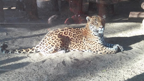
Photo
Where is located Papagayo-Zoo
Papagayo-Zoo — local attraction, which is located at Lic. Manuel Gómez Morin s/n, Fracc Magallanes, Parque Ignacio Manuel Altamirano, 39340 Acapulco de Juárez, Gro., Mexico and belongs to the category — zoo. Average visitor rating for this place — 4.2 (according to 261 rating, information from open sources and relevant for 2022).
Exact location — Papagayo-Zoo, marked on the map with a red marker.
You can get directions to Papagayo-Zoo on the map from your location.
What else is interesting in Acapulco? You can see all the sights if you go to the city page.
Coordinates
Papagayo-Zoo, Mexico coordinates in decimal format: latitude — 16.860513214909673, longitude — -99.88479469289678. When converted to degrees, minutes, seconds Papagayo-Zoo has the following coordinates: 16°51′37.85 north latitude and -99°53′5.26 east longitude.
Nearby cities
The largest cities that are located nearby:
- Chilpancingo — 86 km
- Iguala — 168 km
- Jiutepec — 235 km
- Cuautla — 236 km
- Cuernavaca — 238 km
- Metepec — 266 km
- Toluca — 268 km
- Chalco de Díaz Covarrubias — 285 km
- Ixtapaluca — 290 km
- Ciudad Nezahualcóyotl — 295 km
- Naucalpan — 297 km
- Puebla — 298 km
- Chimalhuacan — 300 km
- Tlalnepantla — 304 km
- Ciudad López Mateos — 305 km
- Texcoco — 310 km
- Buenavista — 312 km
- Ecatepec — 315 km
- Tehuacán — 315 km
Distance to the capital
Distance to the capital (Mexico City) is about — 297 km.