
 Bel-Ha
San Jose El Alto
El Porvenir
Nueva Palestina
Santa Lucía
Chemax
La Morita
Temoac
Zacualpan
Bel-Ha
San Jose El Alto
El Porvenir
Nueva Palestina
Santa Lucía
Chemax
La Morita
Temoac
Zacualpan
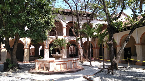
Exconvento de Santo Domingo on the map, Tuxtla Gutiérrez, Mexico
Photo
Where is located Exconvento de Santo Domingo
Exconvento de Santo Domingo — local attraction, which is located at Av. Mexicanidad Chiapaneca 10, Centro, 29160 Chis., Mexico and belongs to the category — museum. Average visitor rating for this place — 4.4 (according to 331 rating, information from open sources and relevant for 2022).
Exact location — Exconvento de Santo Domingo, marked on the map with a red marker.
You can get directions to Exconvento de Santo Domingo on the map from your location.
What else is interesting in Tuxtla Gutiérrez? You can see all the sights if you go to the city page.
Coordinates
Exconvento de Santo Domingo, Mexico coordinates in decimal format: latitude — 16.70653800672427, longitude — -93.01810199289888. When converted to degrees, minutes, seconds Exconvento de Santo Domingo has the following coordinates: 16°42′23.54 north latitude and -93°1′5.17 east longitude.
Nearby cities
The largest cities that are located nearby:
- San Cristóbal de las Casas — 49 km
- Villahermosa — 138 km
- Minatitlán — 204 km
- Coatzacoalcos — 209 km
- Tapachula — 223 km
- Ciudad del Carmen — 250 km
- Quetzaltenango
 (Guatemala) — 272 km
 - San Juan Sacatepéquez (Guatemala) — 346 km
- Guatemala City (Guatemala) — 362 km
- Villa Nueva (Guatemala) — 365 km
- Escuintla (Guatemala) — 367 km
- Villa Canales (Guatemala) — 374 km
- Oaxaca — 384 km
- Campeche — 433 km
- Córdoba — 464 km
- Orizaba — 479 km
- Santa Ana
 (El Salvador) — 488 km
 - Tehuacán — 489 km
- Xalapa — 503 km
Distance to the capital
Distance to the capital (Mexico City) is about — 714 km.