
 Bel-Ha
San Jose El Alto
El Porvenir
Nueva Palestina
Santa Lucía
Chemax
La Morita
Temoac
Zacualpan
Bel-Ha
San Jose El Alto
El Porvenir
Nueva Palestina
Santa Lucía
Chemax
La Morita
Temoac
Zacualpan
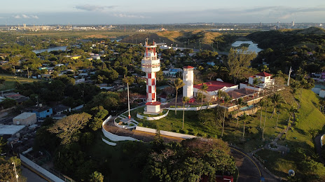
El Faro De Villa Allende Y El Museo. on the map, Coatzacoalcos, Mexico
Photo
Where is located El Faro De Villa Allende Y El Museo.
El Faro De Villa Allende Y El Museo. — local attraction, which is located at 5 de Febrero 300, El Faro, 96380 Allende, Ver., Mexico and belongs to the category — museum. Average visitor rating for this place — 4.6 (according to 72 ratings, information from open sources and relevant for 2022).
Exact location — El Faro De Villa Allende Y El Museo., marked on the map with a red marker.
You can get directions to El Faro De Villa Allende Y El Museo. on the map from your location.
What else is interesting in Coatzacoalcos? You can see all the sights if you go to the city page.
Coordinates
El Faro De Villa Allende Y El Museo., Mexico coordinates in decimal format: latitude — 18.150297822659496, longitude — -94.40086859287852. When converted to degrees, minutes, seconds El Faro De Villa Allende Y El Museo. has the following coordinates: 18°9′1.07 north latitude and -94°24′3.13 east longitude.
Nearby cities
The largest cities that are located nearby:
- Minatitlán — 19 km
- Villahermosa — 160 km
- Tuxtla Gutiérrez — 210 km
- San Cristóbal de las Casas — 247 km
- Oaxaca — 267 km
- Córdoba — 271 km
- Ciudad del Carmen — 284 km
- Orizaba — 288 km
- Xalapa — 299 km
- Tehuacán — 311 km
- Martínez de la Torre — 344 km
- Puebla — 404 km
- Poza Rica de Hidalgo — 408 km
- Tapachula — 427 km
- Campeche — 449 km
- Tulancingo — 459 km
- Cuautla — 476 km
- Ixtapaluca — 479 km
- Chalco de Díaz Covarrubias — 480 km
Distance to the capital
Distance to the capital (Mexico City) is about — 518 km.