
 Bel-Ha
San Jose El Alto
El Porvenir
Nueva Palestina
Santa Lucía
Chemax
La Morita
Temoac
Zacualpan
Bel-Ha
San Jose El Alto
El Porvenir
Nueva Palestina
Santa Lucía
Chemax
La Morita
Temoac
Zacualpan
Cerro El Muhi on the map, Zimapan, Mexico
Photo
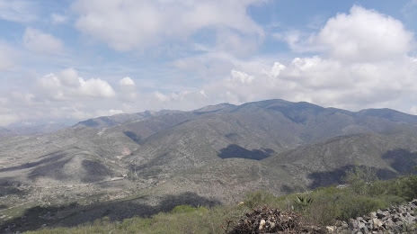
Where is located Cerro El Muhi
Cerro El Muhi — local attraction, which is located at Centro, 42344 Zimapan, Hidalgo, Mexico and belongs to the category — park. Average visitor rating for this place — 4.6 (according to 13 ratings, information from open sources and relevant for 2022).
Exact location — Cerro El Muhi, marked on the map with a red marker.
You can get directions to Cerro El Muhi on the map from your location.
What else is interesting in Zimapan? You can see all the sights if you go to the city page.
Coordinates
Cerro El Muhi, Mexico coordinates in decimal format: latitude — 20.7482613549748, longitude — -99.35409229283785. When converted to degrees, minutes, seconds Cerro El Muhi has the following coordinates: 20°44′53.74 north latitude and -99°21′14.73 east longitude.
Nearby cities
The largest cities that are located nearby:
- San Juan del Río — 73 km
- Pachuca — 95 km
- Santiago de Querétaro — 105 km
- Cuautitlán Izcalli — 121 km
- Ojo de Agua — 122 km
- Coacalco — 125 km
- Buenavista — 127 km
- Tulancingo — 128 km
- Ecatepec — 130 km
- Ciudad López Mateos — 131 km
- Tlalnepantla — 134 km
- Tantoyuca — 137 km
- Naucalpan — 139 km
- Texcoco — 145 km
- Celaya — 150 km
- Chimalhuacan — 151 km
- Ciudad Nezahualcóyotl — 153 km
- Toluca — 163 km
- Metepec — 165 km
Distance to the capital
Distance to the capital (Mexico City) is about — 148 km.