
 Bel-Ha
San Jose El Alto
El Porvenir
Nueva Palestina
Santa Lucía
Chemax
La Morita
Temoac
Zacualpan
Bel-Ha
San Jose El Alto
El Porvenir
Nueva Palestina
Santa Lucía
Chemax
La Morita
Temoac
Zacualpan
Catedral de Irapuato on the map, Irapuato, Mexico
Photo
Where is located Catedral de Irapuato
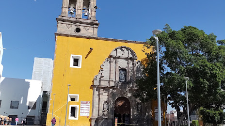
Catedral de Irapuato — local attraction, which is located at Pzla. Abasolo 271, Col. Centro, 36500 Irapuato, Gto., Mexico and belongs to the category — catholic cathedral. Average visitor rating for this place — 4.5 (according to 999 ratings, information from open sources and relevant for 2022).
Exact location — Catedral de Irapuato, marked on the map with a red marker.
You can get directions to Catedral de Irapuato on the map from your location.
What else is interesting in Irapuato? You can see all the sights if you go to the city page.
Coordinates
Catedral de Irapuato, Mexico coordinates in decimal format: latitude — 20.674768720945742, longitude — -101.34692309283909. When converted to degrees, minutes, seconds Catedral de Irapuato has the following coordinates: 20°40′29.17 north latitude and -101°20′48.92 east longitude.
Nearby cities
The largest cities that are located nearby:
- Salamanca — 20 km
- Celaya — 59 km
- León — 60 km
- Santiago de Querétaro — 100 km
- Morelia — 109 km
- Zamora — 123 km
- San Juan del Río — 146 km
- Uruapan — 158 km
- Aguascalientes — 164 km
- San Luis Potosi — 168 km
- Soledad de Graciano Sánchez — 172 km
- Tonalá — 195 km
- Tlaquepaque — 203 km
- Guadalajara — 206 km
- Zapopan — 213 km
- Toluca — 235 km
- Metepec — 242 km
- Cuautitlán Izcalli — 247 km
- Ciudad López Mateos — 250 km
Distance to the capital
Distance to the capital (Mexico City) is about — 269 km.