
 Litoral Del Bajo San Juan
El Cantón de San Pablo
Juan Frío
Santa Barbara
El Juncal
Dibulla
Vereda Campo Alegre
San Pablo
Guaramito
Litoral Del Bajo San Juan
El Cantón de San Pablo
Juan Frío
Santa Barbara
El Juncal
Dibulla
Vereda Campo Alegre
San Pablo
Guaramito
Finca El Paraiso on the map, Villavicencio, Colombia
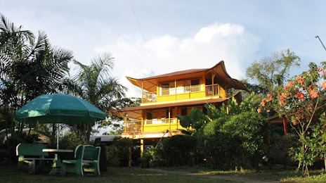
Photo
Where is located Finca El Paraiso
Finca El Paraiso — local attraction, which is located at Vereda, San Cayetano, Acacías, Meta, Colombia and belongs to the category — theme park. Average visitor rating for this place — 4.2 (according to 128 ratings, information from open sources and relevant for 2022).
Exact location — Finca El Paraiso, marked on the map with a red marker.
You can get directions to Finca El Paraiso on the map from your location.
What else is interesting in Villavicencio? You can see all the sights if you go to the city page.
Coordinates
Finca El Paraiso, Colombia coordinates in decimal format: latitude — 4.090654041336617, longitude — -73.65989631003374. When converted to degrees, minutes, seconds Finca El Paraiso has the following coordinates: 4°5′26.35 north latitude and -73°39′35.63 east longitude.
Nearby cities
The largest cities that are located nearby:
- Soacha — 81 km
- Girardot — 131 km
- Tunja — 158 km
- Ibagué — 180 km
- Sogamoso — 191 km
- Neiva — 228 km
- Armenia — 229 km
- Manizales — 232 km
- Dos Quebradas — 237 km
- Pereira — 239 km
- Cartago — 261 km
- Tuluá — 283 km
- Buga — 296 km
- Palmira — 302 km
- Envigado — 312 km
- Itagüi — 313 km
- Medellín — 318 km
- Bello — 322 km
- Barrancabermeja — 323 km
Distance to the capital
Distance to the capital (Bogota) is about — 73 km.