
 Belém
Maranguape
Paranaguá
Paranaguá
Monte Alegre
Alvorada de Minas
Bragança
Laguna
Ibiporã
Belém
Maranguape
Paranaguá
Paranaguá
Monte Alegre
Alvorada de Minas
Bragança
Laguna
Ibiporã
Parque Circuito on the map, Porto Velho, Brazil
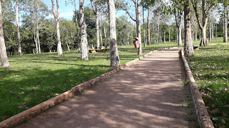
Photo
Where is located Parque Circuito
Parque Circuito — local attraction, which is located at Av. Lauro Sodré, 2983 - Olaria, Porto Velho - RO, 76803-460, Brazil and belongs to the category — park. Average visitor rating for this place — 4.4 (according to 626 ratings, information from open sources and relevant for 2022).
Exact location — Parque Circuito, marked on the map with a red marker.
You can get directions to Parque Circuito on the map from your location.
What else is interesting in Porto Velho? You can see all the sights if you go to the city page.
Coordinates
Parque Circuito, Brazil coordinates in decimal format: latitude — -8.732021725094668, longitude — -63.90101999298139. When converted to degrees, minutes, seconds Parque Circuito has the following coordinates: -8°43′55.28 north latitude and -63°54′3.67 east longitude.
Nearby cities
The largest cities that are located nearby:
- White River — 448 km
- Manaus — 757 km
- Sinop — 970 km
- Cochabamba
 (Bolivia) — 983 km
 - Juliaca
 (Peru) — 998 km
 - Santa Cruz de la Sierra (Bolivia) — 1011 km
- Cusco (Peru) — 1015 km
- Fist (Peru) — 1018 km
- Oruro (Bolivia) — 1072 km
- Cuiaba — 1124 km
- Várzea Grande — 1124 km
- Sucre (Bolivia) — 1143 km
- Pucallpa (Peru) — 1169 km
- Arequipa (Peru) — 1171 km
- Iquitos (Peru) — 1171 km
- Potosi (Bolivia) — 1211 km
- Ayacucho (Peru) — 1213 km
- Tacna (Peru) — 1221 km
- Santarém — 1233 km