
 Litoral Del Bajo San Juan
El Cantón de San Pablo
Juan Frío
Santa Barbara
El Juncal
Dibulla
Vereda Campo Alegre
San Pablo
Guaramito
Litoral Del Bajo San Juan
El Cantón de San Pablo
Juan Frío
Santa Barbara
El Juncal
Dibulla
Vereda Campo Alegre
San Pablo
Guaramito
Parroquia Santa Ana - Sabaneta on the map, Envigado, Colombia
Photo
Where is located Parroquia Santa Ana - Sabaneta
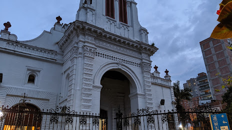
Parroquia Santa Ana - Sabaneta — local attraction, which is located at Cl. 70 Sur ##43B - 49, Sabaneta, Antioquia, Colombia and belongs to the category — catholic church. Average visitor rating for this place — 4.8 (according to 672 ratings, information from open sources and relevant for 2022).
Exact location — Parroquia Santa Ana - Sabaneta, marked on the map with a red marker.
You can get directions to Parroquia Santa Ana - Sabaneta on the map from your location.
What else is interesting in Envigado? You can see all the sights if you go to the city page.
Coordinates
Parroquia Santa Ana - Sabaneta, Colombia coordinates in decimal format: latitude — 6.151131326083322, longitude — -75.61553389299705. When converted to degrees, minutes, seconds Parroquia Santa Ana - Sabaneta has the following coordinates: 6°9′4.07 north latitude and -75°36′55.92 east longitude.
Nearby cities
The largest cities that are located nearby:
- Itagüi — 2 km
- Medellín — 11 km
- Bello — 18 km
- Manizales — 123 km
- Dos Quebradas — 148 km
- Pereira — 151 km
- Cartago — 161 km
- Armenia — 182 km
- Ibagué — 196 km
- Barrancabermeja — 215 km
- Girardot — 225 km
- Soacha — 232 km
- Tuluá — 240 km
- Tunja — 257 km
- Buga — 263 km
- Giron — 283 km
- Monteria — 287 km
- Bucaramanga — 291 km
- Floridablanca — 292 km
Distance to the capital
Distance to the capital (Bogota) is about — 243 km.