
 Manuel María Caballero
Santa Cruz Department
Pozo del Tigre
Motacucito
Colquiri
Inquisivi
Provincia de Andrés Ibáñez
Yacuíba
Tarija
Manuel María Caballero
Santa Cruz Department
Pozo del Tigre
Motacucito
Colquiri
Inquisivi
Provincia de Andrés Ibáñez
Yacuíba
Tarija
Catedral Tarija on the map, Tarija, Bolivia
Photo
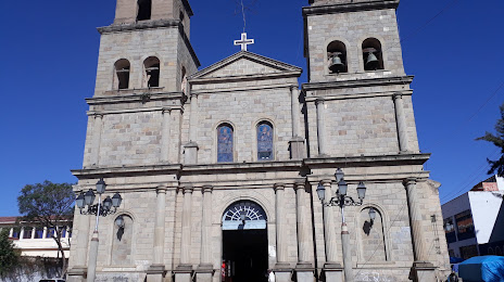
Where is located Catedral Tarija
Catedral Tarija — local attraction, which is located at Pje. Baldiviezo, Tarija, Bolivia and belongs to the category — cathedral. Average visitor rating for this place — 4.4 (according to 77 ratings, information from open sources and relevant for 2022).
Exact location — Catedral Tarija, marked on the map with a red marker.
You can get directions to Catedral Tarija on the map from your location.
What else is interesting in Tarija? You can see all the sights if you go to the city page.
Coordinates
Catedral Tarija, Bolivia coordinates in decimal format: latitude — -21.533081145921738, longitude — -64.73594259282464. When converted to degrees, minutes, seconds Catedral Tarija has the following coordinates: -21°31′59.09 north latitude and -64°44′9.39 east longitude.
Nearby cities
The largest cities that are located nearby:
- Potosi — 242 km
- Sucre — 283 km
- San Salvador de Jujuy
 (Argentina) — 299 km
 - Salta (Argentina) — 366 km
- Calama
 (Chile) — 440 km
 - Santa Cruz de la Sierra — 445 km
- Oruro — 467 km
- Cochabamba — 483 km
- Iquique (Chile) — 580 km
- San Miguel de Tucuman (Argentina) — 585 km
- Antofagasta (Chile) — 620 km
- Arica (Chile) — 676 km
- Santiago del Estero (Argentina) — 693 km
- Tacna
 (Peru) — 699 km
 - Catamarca (Argentina) — 774 km
- Asuncion
 (Paraguay) — 822 km
 - Lambare (Paraguay) — 827 km
- Formosa (Argentina) — 829 km
- Fernando De La Mora (Paraguay) — 832 km
Distance to the capital
Distance to the capital (Nuestra Señora de La Paz) is about — 665 km.