
 Belém
Maranguape
Paranaguá
Paranaguá
Monte Alegre
Alvorada de Minas
Bragança
Laguna
Ibiporã
Belém
Maranguape
Paranaguá
Paranaguá
Monte Alegre
Alvorada de Minas
Bragança
Laguna
Ibiporã
Laranjal Beach (Praia do Laranjal) on the map, Rio Grande, Brazil
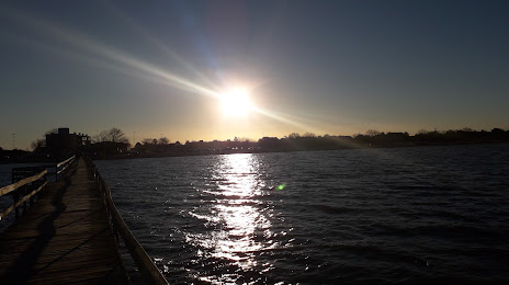
Photo
Where is located Laranjal Beach (Praia do Laranjal)
Laranjal Beach (Praia do Laranjal) — local attraction, which is located at Av. Dr. Antônio Augusto de Assunção, 9120 - Laranjal, Pelotas - RS, 96090-240, Brazil and belongs to the category — scenic spot. Average visitor rating for this place — 4.7 (according to 1265 ratings, information from open sources and relevant for 2022).
Exact location — Laranjal Beach (Praia do Laranjal), marked on the map with a red marker.
You can get directions to Laranjal Beach (Praia do Laranjal) on the map from your location.
What else is interesting in Rio Grande? You can see all the sights if you go to the city page.
Coordinates
Laranjal Beach (Praia do Laranjal), Brazil coordinates in decimal format: latitude — -31.758986538140153, longitude — -52.22836569260941. When converted to degrees, minutes, seconds Laranjal Beach (Praia do Laranjal) has the following coordinates: -31°45′32.35 north latitude and -52°13′42.12 east longitude.
Nearby cities
The largest cities that are located nearby:
- Pelotas — 37 km
- Guaíba — 226 km
- Porto Alegre — 237 km
- Viamão — 240 km
- Cachoeirinha — 250 km
- Canoas — 251 km
- Gravataí — 255 km
- Santa Cruz do Sul — 258 km
- São Leopoldo — 268 km
- Novo Hamburgo — 276 km
- Santa Maria — 307 km
- Caxias do Sul — 330 km
- Passo Fundo — 419 km
- Criciúma — 457 km
- Montevideo
 (Uruguay) — 486 km
 - Lages — 498 km
- Uruguaiana — 540 km
- Chapecó — 548 km
- Concordia
 (Argentina) — 562 km