
 Belém
Maranguape
Paranaguá
Paranaguá
Monte Alegre
Alvorada de Minas
Bragança
Laguna
Ibiporã
Belém
Maranguape
Paranaguá
Paranaguá
Monte Alegre
Alvorada de Minas
Bragança
Laguna
Ibiporã
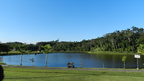
Municipal Park Jorge Hardt (Parque Municipal Jorge Hardt) on the map, Indaial, Brazil
Photo
Where is located Municipal Park Jorge Hardt (Parque Municipal Jorge Hardt)
Municipal Park Jorge Hardt (Parque Municipal Jorge Hardt) — local attraction, which is located at Ribeirão das Pedras, Indaial - State of Santa Catarina, 89130-000, Brazil and belongs to the category — city park. Average visitor rating for this place — 4.4 (according to 758 ratings, information from open sources and relevant for 2022).
Exact location — Municipal Park Jorge Hardt (Parque Municipal Jorge Hardt), marked on the map with a red marker.
You can get directions to Municipal Park Jorge Hardt (Parque Municipal Jorge Hardt) on the map from your location.
What else is interesting in Indaial? You can see all the sights if you go to the city page.
Coordinates
Municipal Park Jorge Hardt (Parque Municipal Jorge Hardt), Brazil coordinates in decimal format: latitude — -26.925956043387135, longitude — -49.247462392720635. When converted to degrees, minutes, seconds Municipal Park Jorge Hardt (Parque Municipal Jorge Hardt) has the following coordinates: -26°55′33.44 north latitude and -49°14′50.86 east longitude.
Nearby cities
The largest cities that are located nearby:
- Blumenau — 16 km
- Jaraguá do Sul — 49 km
- Itajaí — 56 km
- Joinville — 76 km
- São José — 98 km
- Palhoça — 99 km
- Florianópolis — 102 km
- Araucária — 146 km
- Lages — 147 km
- São José dos Pinhais — 151 km
- Pinhais — 161 km
- Curitiba — 163 km
- Paranaguá — 169 km
- Colombo — 178 km
- Criciúma — 196 km
- Guarapuava — 278 km
- Caxias do Sul — 313 km
- Chapecó — 333 km
- Passo Fundo — 344 km