
 Belém
Maranguape
Paranaguá
Paranaguá
Monte Alegre
Alvorada de Minas
Bragança
Laguna
Ibiporã
Belém
Maranguape
Paranaguá
Paranaguá
Monte Alegre
Alvorada de Minas
Bragança
Laguna
Ibiporã
Praia das Areias Negras on the map, Rio das Ostras, Brazil
Photo
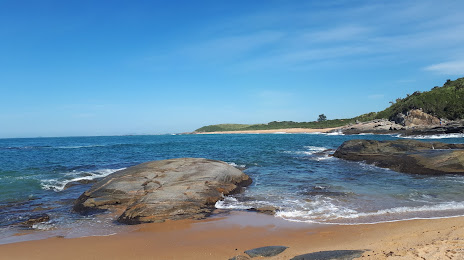
Where is located Praia das Areias Negras
Praia das Areias Negras — local attraction, which is located at no data and belongs to the category — -. Average visitor rating for this place — 4.6 (according to 1124 ratings, information from open sources and relevant for 2022).
Exact location — Praia das Areias Negras, marked on the map with a red marker.
You can get directions to Praia das Areias Negras on the map from your location.
What else is interesting in Rio das Ostras? You can see all the sights if you go to the city page.
Coordinates
Praia das Areias Negras, Brazil coordinates in decimal format: latitude — -22.529939055257923, longitude — -41.92576994280698. When converted to degrees, minutes, seconds Praia das Areias Negras has the following coordinates: -22°31′47.78 north latitude and -41°55′32.77 east longitude.
Nearby cities
The largest cities that are located nearby:
- Macaé — 23 km
- Cabo Frio — 41 km
- Araruama — 54 km
- Itaboraí — 97 km
- Teresópolis — 106 km
- Magé — 112 km
- São Gonçalo — 119 km
- Niterói — 125 km
- Petrópolis — 126 km
- Rio de Janeiro — 132 km
- Duque de Caxias — 141 km
- São João de Meriti — 148 km
- Belford Roxo — 150 km
- Nilópolis — 153 km
- Nova Iguaçu — 156 km
- Queimados — 165 km
- Juiz de Fora — 167 km
- Cachoeiro de Itapemirim — 204 km
- Volta Redonda — 219 km