
 Belém
Maranguape
Paranaguá
Paranaguá
Monte Alegre
Alvorada de Minas
Bragança
Laguna
Ibiporã
Belém
Maranguape
Paranaguá
Paranaguá
Monte Alegre
Alvorada de Minas
Bragança
Laguna
Ibiporã
Bauru Municipal Botanical Garden on the map, Bauru, Brazil
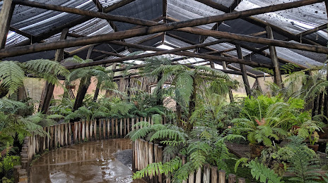
Photo
Where is located Bauru Municipal Botanical Garden
Bauru Municipal Botanical Garden — local attraction, which is located at Rod. Cmte. João Ribeiro de Barros, Km 232 - s/n - Tangaras, Bauru - SP, 17035-245, Brazil and belongs to the category — botanical garden. Average visitor rating for this place — 4.8 (according to 2378 ratings, information from open sources and relevant for 2022).
Exact location — Bauru Municipal Botanical Garden, marked on the map with a red marker.
You can get directions to Bauru Municipal Botanical Garden on the map from your location.
What else is interesting in Bauru? You can see all the sights if you go to the city page.
Coordinates
Bauru Municipal Botanical Garden, Brazil coordinates in decimal format: latitude — -22.343450348649544, longitude — -49.01747059281045. When converted to degrees, minutes, seconds Bauru Municipal Botanical Garden has the following coordinates: -22°20′36.42 north latitude and -49°1′2.89 east longitude.
Nearby cities
The largest cities that are located nearby:
- Botucatu — 89 km
- Marília — 92 km
- Araraquara — 108 km
- São Carlos — 124 km
- Catanduva — 131 km
- Assis — 144 km
- Piracicaba — 151 km
- Rio Claro — 153 km
- Araras — 172 km
- Birigui — 174 km
- Itapetininga — 174 km
- Santa Bárbara D'Oeste — 175 km
- Ribeirão Preto — 180 km
- Americana — 182 km
- Sumaré — 190 km
- Hortolândia — 197 km
- Barretos — 201 km
- Indaiatuba — 207 km
- Itu — 207 km