
 Belém
Maranguape
Paranaguá
Paranaguá
Monte Alegre
Alvorada de Minas
Bragança
Laguna
Ibiporã
Belém
Maranguape
Paranaguá
Paranaguá
Monte Alegre
Alvorada de Minas
Bragança
Laguna
Ibiporã
Magic Gardens on the map, Ribeirão Preto, Brazil
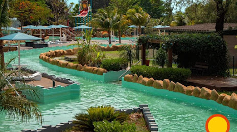
Photo
Where is located Magic Gardens
Magic Gardens — local attraction, which is located at Av. Jornalista Antônio Carlos Pinho, Santana, 2501 - Jardim Orestes Lopes de Camargo, Ribeirão Preto - SP, 14066-220, Brazil and belongs to the category — water park. Average visitor rating for this place — 4.7 (according to 3400 ratings, information from open sources and relevant for 2022).
Exact location — Magic Gardens, marked on the map with a red marker.
You can get directions to Magic Gardens on the map from your location.
What else is interesting in Ribeirão Preto? You can see all the sights if you go to the city page.
Coordinates
Magic Gardens, Brazil coordinates in decimal format: latitude — -21.123698841311956, longitude — -47.832312992831675. When converted to degrees, minutes, seconds Magic Gardens has the following coordinates: -21°7′25.32 north latitude and -47°49′56.33 east longitude.
Nearby cities
The largest cities that are located nearby:
- Araraquara — 78 km
- Franca — 82 km
- São Carlos — 93 km
- Barretos — 104 km
- Catanduva — 120 km
- Araras — 139 km
- Rio Claro — 140 km
- Poços de Caldas — 145 km
- Uberaba — 158 km
- Piracicaba — 174 km
- Bauru — 180 km
- Santa Bárbara D'Oeste — 180 km
- Americana — 180 km
- Sumaré — 191 km
- Hortolândia — 196 km
- Botucatu — 200 km
- Campinas — 207 km
- Indaiatuba — 221 km
- Itu — 236 km