
 Belém
Maranguape
Paranaguá
Paranaguá
Monte Alegre
Alvorada de Minas
Bragança
Laguna
Ibiporã
Belém
Maranguape
Paranaguá
Paranaguá
Monte Alegre
Alvorada de Minas
Bragança
Laguna
Ibiporã
Parque Antenor Martins on the map, Dourados, Brazil
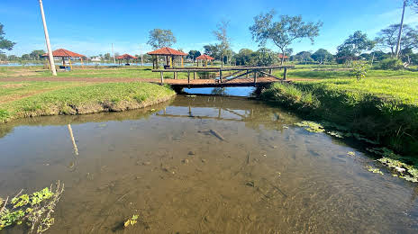
Photo
Where is located Parque Antenor Martins
Parque Antenor Martins — local attraction, which is located at Av. José Roberto Teixeira, 114-216 - Jardim Florida, Dourados - MS, 79822-090, Brazil and belongs to the category — ecological park. Average visitor rating for this place — 4.2 (according to 812 ratings, information from open sources and relevant for 2022).
Exact location — Parque Antenor Martins, marked on the map with a red marker.
You can get directions to Parque Antenor Martins on the map from your location.
What else is interesting in Dourados? You can see all the sights if you go to the city page.
Coordinates
Parque Antenor Martins, Brazil coordinates in decimal format: latitude — -22.22890009606805, longitude — -54.8324975025217. When converted to degrees, minutes, seconds Parque Antenor Martins has the following coordinates: -22°13′44.04 north latitude and -54°49′56.99 east longitude.
Nearby cities
The largest cities that are located nearby:
- Campo Grande — 195 km
- Maringá — 321 km
- Cascavel — 331 km
- Presidente Prudente — 350 km
- Ciudad del Este
 (Paraguay) — 365 km
 - Foz do Iguaçu — 365 km
- Apucarana — 370 km
- Luque (Paraguay) — 430 km
- Capiata (Paraguay) — 436 km
- San Lorenzo (Paraguay) — 438 km
- Fernando De La Mora (Paraguay) — 439 km
- Asuncion (Paraguay) — 440 km
- Lambare (Paraguay) — 444 km
- Assis — 451 km
- Birigui — 472 km
- Guarapuava — 484 km
- Marília — 498 km
- Formosa
 (Argentina) — 551 km
 - Posadas (Argentina) — 578 km