
 Belém
Maranguape
Paranaguá
Paranaguá
Monte Alegre
Alvorada de Minas
Bragança
Laguna
Ibiporã
Belém
Maranguape
Paranaguá
Paranaguá
Monte Alegre
Alvorada de Minas
Bragança
Laguna
Ibiporã
Ilha das Garças on the map, Vila Velha, Brazil
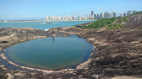
Photo
Where is located Ilha das Garças
Ilha das Garças — local attraction, which is located at Vila Velha, State of Espírito Santo, Brazil and belongs to the category — scenic spot. Average visitor rating for this place — 4.9 (according to 18 ratings, information from open sources and relevant for 2022).
Exact location — Ilha das Garças, marked on the map with a red marker.
You can get directions to Ilha das Garças on the map from your location.
What else is interesting in Vila Velha? You can see all the sights if you go to the city page.
Coordinates
Ilha das Garças, Brazil coordinates in decimal format: latitude — -20.380667942196055, longitude — -40.296454202553086. When converted to degrees, minutes, seconds Ilha das Garças has the following coordinates: -20°22′50.4 north latitude and -40°17′47.24 east longitude.
Nearby cities
The largest cities that are located nearby:
- Cariacica — 16 km
- Serra — 25 km
- Guarapari — 42 km
- Colatina — 100 km
- Cachoeiro de Itapemirim — 102 km
- Linhares — 108 km
- Valadares Governor — 240 km
- Coronel Fabriciano — 260 km
- Macaé — 272 km
- Teófilo Otoni — 303 km
- Cabo Frio — 332 km
- Araruama — 347 km
- Juiz de Fora — 350 km
- Teresópolis — 357 km
- Sabará — 371 km
- Barbacena — 371 km
- Itaboraí — 374 km
- Magé — 379 km
- Petrópolis — 379 km