
 Belém
Maranguape
Paranaguá
Paranaguá
Monte Alegre
Alvorada de Minas
Bragança
Laguna
Ibiporã
Belém
Maranguape
Paranaguá
Paranaguá
Monte Alegre
Alvorada de Minas
Bragança
Laguna
Ibiporã
Florybal Magic Park Land on the map, Gramado, Brazil
Photo
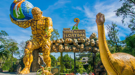
Where is located Florybal Magic Park Land
Florybal Magic Park Land — local attraction, which is located at Rodovia RS-466, 1630 - Jardim dos Pinheiros II, Canela - RS, 95680-000, Brazil and belongs to the category — theme park. Average visitor rating for this place — 4.6 (according to 14374 ratings, information from open sources and relevant for 2022).
Exact location — Florybal Magic Park Land, marked on the map with a red marker.
You can get directions to Florybal Magic Park Land on the map from your location.
What else is interesting in Gramado? You can see all the sights if you go to the city page.
Coordinates
Florybal Magic Park Land, Brazil coordinates in decimal format: latitude — -29.349064115348334, longitude — -50.83315980237612. When converted to degrees, minutes, seconds Florybal Magic Park Land has the following coordinates: -29°20′56.63 north latitude and -50°49′59.38 east longitude.
Nearby cities
The largest cities that are located nearby:
- Caxias do Sul — 37 km
- Novo Hamburgo — 43 km
- São Leopoldo — 50 km
- Gravataí — 64 km
- Canoas — 67 km
- Cachoeirinha — 67 km
- Viamão — 79 km
- Porto Alegre — 80 km
- Guaíba — 92 km
- Santa Cruz do Sul — 155 km
- Criciúma — 165 km
- Lages — 181 km
- Passo Fundo — 194 km
- Santa Maria — 284 km
- Palhoça — 288 km
- São José — 293 km
- Pelotas — 298 km
- Florianópolis — 301 km
- Chapecó — 304 km