
 Belém
Maranguape
Paranaguá
Paranaguá
Monte Alegre
Alvorada de Minas
Bragança
Laguna
Ibiporã
Belém
Maranguape
Paranaguá
Paranaguá
Monte Alegre
Alvorada de Minas
Bragança
Laguna
Ibiporã
Praia Costa Azul - Iriri on the map, Itapemirim, Brazil
Photo
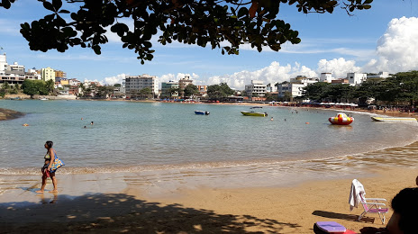
Where is located Praia Costa Azul - Iriri
Praia Costa Azul - Iriri — local attraction, which is located at no data and belongs to the category — -. Average visitor rating for this place — 4.8 (according to 199 ratings, information from open sources and relevant for 2022).
Exact location — Praia Costa Azul - Iriri, marked on the map with a red marker.
You can get directions to Praia Costa Azul - Iriri on the map from your location.
What else is interesting in Itapemirim? You can see all the sights if you go to the city page.
Coordinates
Praia Costa Azul - Iriri, Brazil coordinates in decimal format: latitude — -20.82898814503218, longitude — -40.69471111012199. When converted to degrees, minutes, seconds Praia Costa Azul - Iriri has the following coordinates: -20°49′44.36 north latitude and -40°41′40.96 east longitude.
Nearby cities
The largest cities that are located nearby:
- Cachoeiro de Itapemirim — 35 km
- Guarapari — 51 km
- Vila Velha — 92 km
- Cariacica — 93 km
- Serra — 112 km
- Colatina — 166 km
- Macaé — 180 km
- Linhares — 196 km
- Cabo Frio — 241 km
- Coronel Fabriciano — 249 km
- Araruama — 256 km
- Valadares Governor — 266 km
- Teresópolis — 269 km
- Juiz de Fora — 271 km
- Itaboraí — 283 km
- Magé — 290 km
- Petrópolis — 292 km
- São Gonçalo — 304 km
- Barbacena — 304 km