
 Belém
Maranguape
Paranaguá
Paranaguá
Monte Alegre
Alvorada de Minas
Bragança
Laguna
Ibiporã
Belém
Maranguape
Paranaguá
Paranaguá
Monte Alegre
Alvorada de Minas
Bragança
Laguna
Ibiporã
Parque Municipal do Itabira on the map, Itapemirim, Brazil
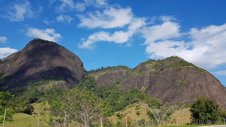
Photo
Where is located Parque Municipal do Itabira
Parque Municipal do Itabira — local attraction, which is located at Rod. BR-482 ES, Brazil and belongs to the category — city park. Average visitor rating for this place — 4.4 (according to 154 ratings, information from open sources and relevant for 2022).
Exact location — Parque Municipal do Itabira, marked on the map with a red marker.
You can get directions to Parque Municipal do Itabira on the map from your location.
What else is interesting in Itapemirim? You can see all the sights if you go to the city page.
Coordinates
Parque Municipal do Itabira, Brazil coordinates in decimal format: latitude — -20.840608353035833, longitude — -41.07154569037072. When converted to degrees, minutes, seconds Parque Municipal do Itabira has the following coordinates: -20°50′26.19 north latitude and -41°4′17.56 east longitude.
Nearby cities
The largest cities that are located nearby:
- Cachoeiro de Itapemirim — 35 km
- Guarapari — 51 km
- Vila Velha — 92 km
- Cariacica — 93 km
- Serra — 112 km
- Colatina — 166 km
- Macaé — 180 km
- Linhares — 196 km
- Cabo Frio — 241 km
- Coronel Fabriciano — 249 km
- Araruama — 256 km
- Valadares Governor — 266 km
- Teresópolis — 269 km
- Juiz de Fora — 271 km
- Itaboraí — 283 km
- Magé — 290 km
- Petrópolis — 292 km
- São Gonçalo — 304 km
- Barbacena — 304 km