
 Belém
Maranguape
Paranaguá
Paranaguá
Monte Alegre
Alvorada de Minas
Bragança
Laguna
Ibiporã
Belém
Maranguape
Paranaguá
Paranaguá
Monte Alegre
Alvorada de Minas
Bragança
Laguna
Ibiporã
INEA - Cunhambebe Park on the map, Mangaratiba, Brazil
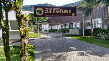
Photo
Where is located INEA - Cunhambebe Park
INEA - Cunhambebe Park — local attraction, which is located at Estr. da Cachoeira, s/n - Vale do Sahy, Mangaratiba - RJ, 23860-000, Brazil and belongs to the category — state park. Average visitor rating for this place — 4.8 (according to 337 ratings, information from open sources and relevant for 2022).
Exact location — INEA - Cunhambebe Park, marked on the map with a red marker.
You can get directions to INEA - Cunhambebe Park on the map from your location.
What else is interesting in Mangaratiba? You can see all the sights if you go to the city page.
Coordinates
INEA - Cunhambebe Park, Brazil coordinates in decimal format: latitude — -22.929360779200298, longitude — -43.99895130250905. When converted to degrees, minutes, seconds INEA - Cunhambebe Park has the following coordinates: -22°55′45.7 north latitude and -43°59′56.22 east longitude.
Nearby cities
The largest cities that are located nearby:
- Angra dos Reis — 28 km
- Barra Mansa — 48 km
- Volta Redonda — 50 km
- Queimados — 57 km
- Nova Iguaçu — 63 km
- Nilópolis — 66 km
- Resende — 68 km
- Belford Roxo — 69 km
- São João de Meriti — 71 km
- Duque de Caxias — 77 km
- Rio de Janeiro — 89 km
- Niterói — 95 km
- São Gonçalo — 101 km
- Petrópolis — 101 km
- Magé — 108 km
- Guaratinguetá — 119 km
- Itaboraí — 122 km
- Teresópolis — 124 km
- Pindamonhangaba — 145 km