
 Belém
Maranguape
Paranaguá
Paranaguá
Monte Alegre
Alvorada de Minas
Bragança
Laguna
Ibiporã
Belém
Maranguape
Paranaguá
Paranaguá
Monte Alegre
Alvorada de Minas
Bragança
Laguna
Ibiporã
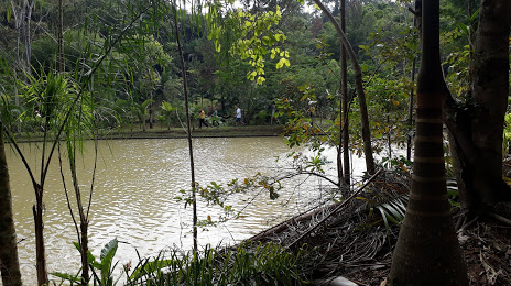
Morrow National Forest (Floresta Nacional de Ibirama) on the map, Ibirama, Brazil
Photo
Where is located Morrow National Forest (Floresta Nacional de Ibirama)
Morrow National Forest (Floresta Nacional de Ibirama) — local attraction, which is located at Estrada Geral Ribeirão Taquaras, SN, Caixa Postal 81, Ribeirão Taquaras, Ibirama-SC, CEP, Apiúna - SC, 89140-000, Brazil and belongs to the category — national forest. Average visitor rating for this place — 4.6 (according to 37 ratings, information from open sources and relevant for 2022).
Exact location — Morrow National Forest (Floresta Nacional de Ibirama), marked on the map with a red marker.
You can get directions to Morrow National Forest (Floresta Nacional de Ibirama) on the map from your location.
What else is interesting in Ibirama? You can see all the sights if you go to the city page.
Coordinates
Morrow National Forest (Floresta Nacional de Ibirama), Brazil coordinates in decimal format: latitude — -27.02407078709648, longitude — -49.45613446479061. When converted to degrees, minutes, seconds Morrow National Forest (Floresta Nacional de Ibirama) has the following coordinates: -27°1′26.65 north latitude and -49°27′22.08 east longitude.
Nearby cities
The largest cities that are located nearby:
- Blumenau — 48 km
- Jaraguá do Sul — 78 km
- Itajaí — 86 km
- Palhoça — 106 km
- São José — 107 km
- Joinville — 108 km
- Florianópolis — 113 km
- Lages — 114 km
- Araucária — 163 km
- São José dos Pinhais — 172 km
- Criciúma — 179 km
- Pinhais — 182 km
- Curitiba — 182 km
- Colombo — 198 km
- Paranaguá — 198 km
- Guarapuava — 267 km
- Caxias do Sul — 282 km
- Chapecó — 304 km
- Passo Fundo — 310 km