
 Belém
Maranguape
Paranaguá
Paranaguá
Monte Alegre
Alvorada de Minas
Bragança
Laguna
Ibiporã
Belém
Maranguape
Paranaguá
Paranaguá
Monte Alegre
Alvorada de Minas
Bragança
Laguna
Ibiporã
Sumidouro State Park on the map, Lagoa Santa, Brazil
Photo
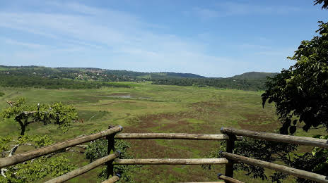
Where is located Sumidouro State Park
Sumidouro State Park — local attraction, which is located at Lagoa Santa, MG, Brazil and belongs to the category — state park. Average visitor rating for this place — 4.5 (according to 928 ratings, information from open sources and relevant for 2022).
Exact location — Sumidouro State Park, marked on the map with a red marker.
You can get directions to Sumidouro State Park on the map from your location.
What else is interesting in Lagoa Santa? You can see all the sights if you go to the city page.
Coordinates
Sumidouro State Park, Brazil coordinates in decimal format: latitude — -19.53605177402712, longitude — -43.94209780256679. When converted to degrees, minutes, seconds Sumidouro State Park has the following coordinates: -19°32′9.79 north latitude and -43°56′31.55 east longitude.
Nearby cities
The largest cities that are located nearby:
- Santa Luzia — 18 km
- Ribeirão das Neves — 24 km
- Sabará — 29 km
- Belo Horizonte — 32 km
- Esmeraldas — 35 km
- Contagem — 37 km
- Sete Lagoas — 41 km
- Ibirité — 47 km
- Betim — 49 km
- Divinópolis — 118 km
- Coronel Fabriciano — 133 km
- Barbacena — 176 km
- Valadares Governor — 221 km
- Juiz de Fora — 243 km
- Patos de Minas — 297 km
- Cachoeiro de Itapemirim — 317 km
- Teófilo Otoni — 319 km
- Volta Redonda — 319 km
- Resende — 319 km