
 Belém
Maranguape
Paranaguá
Paranaguá
Monte Alegre
Alvorada de Minas
Bragança
Laguna
Ibiporã
Belém
Maranguape
Paranaguá
Paranaguá
Monte Alegre
Alvorada de Minas
Bragança
Laguna
Ibiporã
Castelo Furlani on the map, Pederneiras, Brazil
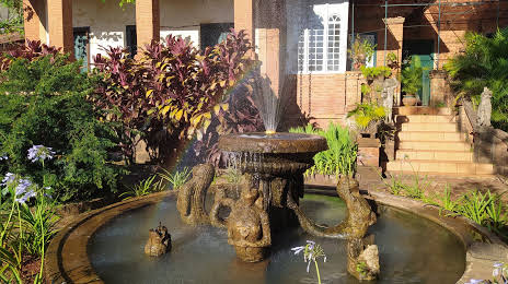
Photo
Where is located Castelo Furlani
Castelo Furlani — local attraction, which is located at R. Monsieur Alba Fernandes, 360 - Jd Anchieta, Pederneiras - SP, 17280-000, Brazil and belongs to the category — castle. Average visitor rating for this place — 4.5 (according to 69 ratings, information from open sources and relevant for 2022).
Exact location — Castelo Furlani, marked on the map with a red marker.
You can get directions to Castelo Furlani on the map from your location.
What else is interesting in Pederneiras? You can see all the sights if you go to the city page.
Coordinates
Castelo Furlani, Brazil coordinates in decimal format: latitude — -22.344528088973064, longitude — -48.77589110251961. When converted to degrees, minutes, seconds Castelo Furlani has the following coordinates: -22°20′40.3 north latitude and -48°46′33.21 east longitude.
Nearby cities
The largest cities that are located nearby:
- Bauru — 29 km
- Botucatu — 69 km
- Araraquara — 87 km
- São Carlos — 98 km
- Marília — 121 km
- Piracicaba — 123 km
- Rio Claro — 124 km
- Catanduva — 136 km
- Araras — 143 km
- Santa Bárbara D'Oeste — 146 km
- Americana — 153 km
- Itapetininga — 156 km
- Sumaré — 162 km
- Ribeirão Preto — 163 km
- Hortolândia — 169 km
- Assis — 171 km
- Indaiatuba — 179 km
- Itu — 181 km
- Campinas — 185 km