
 Belém
Maranguape
Paranaguá
Paranaguá
Monte Alegre
Alvorada de Minas
Bragança
Laguna
Ibiporã
Belém
Maranguape
Paranaguá
Paranaguá
Monte Alegre
Alvorada de Minas
Bragança
Laguna
Ibiporã
St. Anthony's Chapel on the map, Brodowski, Brazil
Photo
Where is located St. Anthony's Chapel
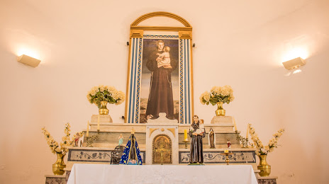
St. Anthony's Chapel — local attraction, which is located at Brodowski - State of São Paulo, 14340-000, Brazil and belongs to the category — catholic church. Average visitor rating for this place — 4.8 (according to 97 ratings, information from open sources and relevant for 2022).
Exact location — St. Anthony's Chapel, marked on the map with a red marker.
You can get directions to St. Anthony's Chapel on the map from your location.
What else is interesting in Brodowski? You can see all the sights if you go to the city page.
Coordinates
St. Anthony's Chapel, Brazil coordinates in decimal format: latitude — -20.993730694885624, longitude — -47.65947880254308. When converted to degrees, minutes, seconds St. Anthony's Chapel has the following coordinates: -20°59′37.43 north latitude and -47°39′34.12 east longitude.
Nearby cities
The largest cities that are located nearby:
- Ribeirão Preto — 26 km
- Franca — 56 km
- Araraquara — 103 km
- Barretos — 106 km
- São Carlos — 116 km
- Catanduva — 138 km
- Uberaba — 140 km
- Poços de Caldas — 143 km
- Araras — 154 km
- Rio Claro — 158 km
- Piracicaba — 193 km
- Americana — 196 km
- Santa Bárbara D'Oeste — 197 km
- Bauru — 205 km
- Sumaré — 206 km
- Hortolândia — 211 km
- Campinas — 221 km
- Botucatu — 225 km
- Indaiatuba — 237 km