
 Belém
Maranguape
Paranaguá
Paranaguá
Monte Alegre
Alvorada de Minas
Bragança
Laguna
Ibiporã
Belém
Maranguape
Paranaguá
Paranaguá
Monte Alegre
Alvorada de Minas
Bragança
Laguna
Ibiporã
Water Park Dona Benta on the map, Bacabal, Brazil
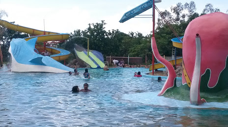
Photo
Where is located Water Park Dona Benta
Water Park Dona Benta — local attraction, which is located at Av. João Alberto, 2, Bacabal - MA, 65700-000, Brazil and belongs to the category — water park. Average visitor rating for this place — 4.0 (according to 189 ratings, information from open sources and relevant for 2022).
Exact location — Water Park Dona Benta, marked on the map with a red marker.
You can get directions to Water Park Dona Benta on the map from your location.
What else is interesting in Bacabal? You can see all the sights if you go to the city page.
Coordinates
Water Park Dona Benta, Brazil coordinates in decimal format: latitude — -4.241599359882323, longitude — -44.81223460271437. When converted to degrees, minutes, seconds Water Park Dona Benta has the following coordinates: -4°14′29.76 north latitude and -44°48′44.04 east longitude.
Nearby cities
The largest cities that are located nearby:
- Caxias — 172 km
- São Luís — 194 km
- Timon — 236 km
- Teresina — 238 km
- Imperatriz — 329 km
- Parnaíba — 363 km
- Castanhal — 474 km
- Marabá — 495 km
- Araguaína — 499 km
- Ananindeua — 507 km
- Belém — 511 km
- Caucaia — 678 km
- Maracanaú — 681 km
- Juazeiro do Norte — 686 km
- Fortaleza — 693 km
- Petrolina — 738 km
- Palmas — 770 km
- Mossoro — 826 km
- Macapá — 839 km