
 Belém
Maranguape
Paranaguá
Paranaguá
Monte Alegre
Alvorada de Minas
Bragança
Laguna
Ibiporã
Belém
Maranguape
Paranaguá
Paranaguá
Monte Alegre
Alvorada de Minas
Bragança
Laguna
Ibiporã
Praia do Acutuba on the map, Iranduba, Brazil
Photo
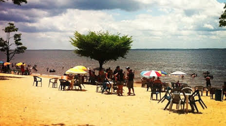
Where is located Praia do Acutuba
Praia do Acutuba — local attraction, which is located at no data and belongs to the category — -. Average visitor rating for this place — 4.6 (according to 175 ratings, information from open sources and relevant for 2022).
Exact location — Praia do Acutuba, marked on the map with a red marker.
You can get directions to Praia do Acutuba on the map from your location.
What else is interesting in Iranduba? You can see all the sights if you go to the city page.
Coordinates
Praia do Acutuba, Brazil coordinates in decimal format: latitude — -3.0959893303292447, longitude — -60.351036772434. When converted to degrees, minutes, seconds Praia do Acutuba has the following coordinates: -3°5′45.56 north latitude and -60°21′3.73 east longitude.
Nearby cities
The largest cities that are located nearby:
- Manaus — 17 km
- Santarém — 603 km
- Boa Vista — 674 km
- Porto Velho — 737 km
- Macapá — 1062 km
- Sinop — 1074 km
- White River — 1123 km
- Georgetown
 (Guyana) — 1131 km
 - Paramaribo
 (Suriname) — 1141 km
 - Marabá — 1230 km
- Belém — 1298 km
- Ciudad Bolivar
 (Venezuela) — 1309 km
 - Ananindeua — 1313 km
- Castanhal — 1364 km
- Araguaína — 1376 km
- Imperatriz — 1412 km
- El Tigre (Venezuela) — 1415 km
- Cuiaba — 1431 km
- Várzea Grande — 1434 km