
 Belém
Maranguape
Paranaguá
Paranaguá
Monte Alegre
Alvorada de Minas
Bragança
Laguna
Ibiporã
Belém
Maranguape
Paranaguá
Paranaguá
Monte Alegre
Alvorada de Minas
Bragança
Laguna
Ibiporã
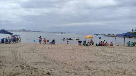
Alegre Beach - Penha (Praia Alegre - Penha) on the map, Penha, Brazil
Photo
Where is located Alegre Beach - Penha (Praia Alegre - Penha)
Alegre Beach - Penha (Praia Alegre - Penha) — local attraction, which is located at no data and belongs to the category — -. Average visitor rating for this place — 4.4 (according to 4792 ratings, information from open sources and relevant for 2022).
Exact location — Alegre Beach - Penha (Praia Alegre - Penha), marked on the map with a red marker.
You can get directions to Alegre Beach - Penha (Praia Alegre - Penha) on the map from your location.
What else is interesting in Penha? You can see all the sights if you go to the city page.
Coordinates
Alegre Beach - Penha (Praia Alegre - Penha), Brazil coordinates in decimal format: latitude — -26.77136772896948, longitude — -48.656750359671264. When converted to degrees, minutes, seconds Alegre Beach - Penha (Praia Alegre - Penha) has the following coordinates: -26°46′16.92 north latitude and -48°39′24.3 east longitude.
Nearby cities
The largest cities that are located nearby:
- Itajaí — 15 km
- Blumenau — 45 km
- Jaraguá do Sul — 53 km
- Joinville — 56 km
- Florianópolis — 91 km
- São José — 93 km
- Palhoça — 96 km
- Paranaguá — 140 km
- São José dos Pinhais — 148 km
- Araucária — 152 km
- Pinhais — 157 km
- Curitiba — 161 km
- Colombo — 174 km
- Lages — 200 km
- Criciúma — 221 km
- Guarapuava — 320 km
- Itapetininga — 358 km
- Caxias do Sul — 360 km
- Praia Grande — 380 km