
 Belém
Maranguape
Paranaguá
Paranaguá
Monte Alegre
Alvorada de Minas
Bragança
Laguna
Ibiporã
Belém
Maranguape
Paranaguá
Paranaguá
Monte Alegre
Alvorada de Minas
Bragança
Laguna
Ibiporã
Praia do Gravatá on the map, Navegantes, Brazil
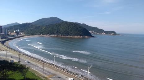
Photo
Where is located Praia do Gravatá
Praia do Gravatá — local attraction, which is located at Av. Prefeito Cirino Adolfo Cabral, 9410-9474 - Gravatá, Navegantes - SC, 88375-000, Brazil and belongs to the category — tourist attraction. Average visitor rating for this place — 4.5 (according to 2798 ratings, information from open sources and relevant for 2022).
Exact location — Praia do Gravatá, marked on the map with a red marker.
You can get directions to Praia do Gravatá on the map from your location.
What else is interesting in Navegantes? You can see all the sights if you go to the city page.
Coordinates
Praia do Gravatá, Brazil coordinates in decimal format: latitude — -26.91505709194036, longitude — -48.71995118067558. When converted to degrees, minutes, seconds Praia do Gravatá has the following coordinates: -26°54′54.21 north latitude and -48°43′11.82 east longitude.
Nearby cities
The largest cities that are located nearby:
- Itajaí — 2 km
- Blumenau — 41 km
- Jaraguá do Sul — 62 km
- Joinville — 68 km
- Florianópolis — 78 km
- São José — 80 km
- Palhoça — 83 km
- Paranaguá — 153 km
- São José dos Pinhais — 160 km
- Araucária — 163 km
- Pinhais — 169 km
- Curitiba — 173 km
- Colombo — 186 km
- Lages — 193 km
- Criciúma — 209 km
- Guarapuava — 326 km
- Caxias do Sul — 350 km
- Itapetininga — 371 km
- Novo Hamburgo — 390 km