
 Belém
Maranguape
Paranaguá
Paranaguá
Monte Alegre
Alvorada de Minas
Bragança
Laguna
Ibiporã
Belém
Maranguape
Paranaguá
Paranaguá
Monte Alegre
Alvorada de Minas
Bragança
Laguna
Ibiporã
St. Michael Beach / SC-Peña on the map, Navegantes, Brazil
Photo
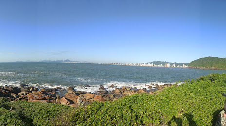
Where is located St. Michael Beach / SC-Peña
St. Michael Beach / SC-Peña — local attraction, which is located at no data and belongs to the category — -. Average visitor rating for this place — 4.3 (according to 4021 rating, information from open sources and relevant for 2022).
Exact location — St. Michael Beach / SC-Peña, marked on the map with a red marker.
You can get directions to St. Michael Beach / SC-Peña on the map from your location.
What else is interesting in Navegantes? You can see all the sights if you go to the city page.
Coordinates
St. Michael Beach / SC-Peña, Brazil coordinates in decimal format: latitude — -26.8231452899267, longitude — -48.61405005399432. When converted to degrees, minutes, seconds St. Michael Beach / SC-Peña has the following coordinates: -26°49′23.32 north latitude and -48°36′50.58 east longitude.
Nearby cities
The largest cities that are located nearby:
- Itajaí — 2 km
- Blumenau — 41 km
- Jaraguá do Sul — 62 km
- Joinville — 68 km
- Florianópolis — 78 km
- São José — 80 km
- Palhoça — 83 km
- Paranaguá — 153 km
- São José dos Pinhais — 160 km
- Araucária — 163 km
- Pinhais — 169 km
- Curitiba — 173 km
- Colombo — 186 km
- Lages — 193 km
- Criciúma — 209 km
- Guarapuava — 326 km
- Caxias do Sul — 350 km
- Itapetininga — 371 km
- Novo Hamburgo — 390 km