
 Litoral Del Bajo San Juan
El Cantón de San Pablo
Juan Frío
Santa Barbara
El Juncal
Dibulla
Vereda Campo Alegre
San Pablo
Guaramito
Litoral Del Bajo San Juan
El Cantón de San Pablo
Juan Frío
Santa Barbara
El Juncal
Dibulla
Vereda Campo Alegre
San Pablo
Guaramito
Cristo Petrolero on the map, Barrancabermeja, Colombia
Photo
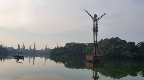
Where is located Cristo Petrolero
Cristo Petrolero — local attraction, which is located at 66, Barrancabermeja, Santander, Colombia and belongs to the category — monument. Average visitor rating for this place — 4.2 (according to 419 ratings, information from open sources and relevant for 2022).
Exact location — Cristo Petrolero, marked on the map with a red marker.
You can get directions to Cristo Petrolero on the map from your location.
What else is interesting in Barrancabermeja? You can see all the sights if you go to the city page.
Coordinates
Cristo Petrolero, Colombia coordinates in decimal format: latitude — 7.0624570577366494, longitude — -73.86927010285983. When converted to degrees, minutes, seconds Cristo Petrolero has the following coordinates: 7°3′44.85 north latitude and -73°52′9.37 east longitude.
Nearby cities
The largest cities that are located nearby:
- Giron — 75 km
- Bucaramanga — 80 km
- Floridablanca — 84 km
- Cúcuta — 173 km
- Tunja — 177 km
- Sogamoso — 180 km
- San Cristobal
 (Venezuela) — 195 km
 - Bello — 204 km
- Medellín — 208 km
- Envigado — 215 km
- Itagüi — 217 km
- Magangué — 260 km
- Soacha — 277 km
- Manizales — 287 km
- Monteria — 290 km
- Sincelejo — 300 km
- Dos Quebradas — 317 km
- Pereira — 321 km
- Girardot — 323 km
Distance to the capital
Distance to the capital (Bogota) is about — 275 km.