
 La Armonía
Timote
Cruz de Piedra
Villa Concepción del Tio
Manantiales
Colonia Italiana
Los Tigres
Puerto Leoni
Campo Santo
La Armonía
Timote
Cruz de Piedra
Villa Concepción del Tio
Manantiales
Colonia Italiana
Los Tigres
Puerto Leoni
Campo Santo
Plaza Rivadavia on the map, Bahía Blanca, Argentina
Photo
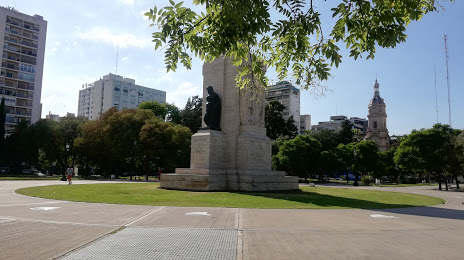
Where is located Plaza Rivadavia
Plaza Rivadavia — local attraction, which is located at Alsina Centro, B8000 Bahía Blanca, Provincia de Buenos Aires, Argentina and belongs to the category — state park. Average visitor rating for this place — 4.2 (according to 11704 ratings, information from open sources and relevant for 2022).
Exact location — Plaza Rivadavia, marked on the map with a red marker.
You can get directions to Plaza Rivadavia on the map from your location.
What else is interesting in Bahía Blanca? You can see all the sights if you go to the city page.
Coordinates
Plaza Rivadavia, Argentina coordinates in decimal format: latitude — -38.71766373481747, longitude — -62.26548510228835. When converted to degrees, minutes, seconds Plaza Rivadavia has the following coordinates: -38°43′3.59 north latitude and -62°15′55.75 east longitude.
Nearby cities
The largest cities that are located nearby:
- Tandil — 314 km
- Mar del Plata — 416 km
- Neuquen — 499 km
- Morón — 558 km
- Trelew — 558 km
- Quilmes — 572 km
- La Plata — 573 km
- San Nicolás — 624 km
- Villa Mercedes — 629 km
- Río Cuarto — 646 km
- Rosario — 654 km
- Montevideo
 (Uruguay) — 696 km
 - San Luis — 706 km
- San Rafael — 715 km
- Parana — 788 km
- Santa Fe — 796 km
- San Carlos de Bariloche — 799 km
- Córdoba — 828 km
- Mendoza — 887 km
Distance to the capital
Distance to the capital (Buenos Aires) is about — 574 km.