
 Litoral Del Bajo San Juan
El Cantón de San Pablo
Juan Frío
Santa Barbara
El Juncal
Dibulla
Vereda Campo Alegre
San Pablo
Guaramito
Litoral Del Bajo San Juan
El Cantón de San Pablo
Juan Frío
Santa Barbara
El Juncal
Dibulla
Vereda Campo Alegre
San Pablo
Guaramito
Simón Bolivar on the map, Monteria, Colombia
Photo
Where is located Simón Bolivar
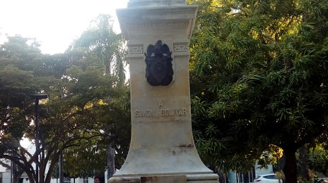
Simón Bolivar — local attraction, which is located at Calle 28 con Carrera 2, Centro, Montería, Córdoba, Colombia and belongs to the category — monument. Average visitor rating for this place — 4.3 (according to 16 ratings, information from open sources and relevant for 2022).
Exact location — Simón Bolivar, marked on the map with a red marker.
You can get directions to Simón Bolivar on the map from your location.
What else is interesting in Monteria? You can see all the sights if you go to the city page.
Coordinates
Simón Bolivar, Colombia coordinates in decimal format: latitude — 8.74837898744591, longitude — -75.88308052193322. When converted to degrees, minutes, seconds Simón Bolivar has the following coordinates: 8°44′54.16 north latitude and -75°52′59.09 east longitude.
Nearby cities
The largest cities that are located nearby:
- Sincelejo — 81 km
- Magangué — 135 km
- Cartagena — 188 km
- Malambo — 262 km
- Soledad — 269 km
- Bello — 269 km
- Barranquilla — 272 km
- Medellín — 276 km
- Envigado — 287 km
- Itagüi — 287 km
- Barrancabermeja — 291 km
- Santa Marta — 330 km
- Valledupar — 344 km
- Giron — 351 km
- Bucaramanga — 352 km
- Floridablanca — 359 km
- Cúcuta — 382 km
- San Miguelito
 (Panama) — 394 km
 - Panama (Panama) — 398 km
Distance to the capital
Distance to the capital (Bogota) is about — 503 km.