
 Litoral Del Bajo San Juan
El Cantón de San Pablo
Juan Frío
Santa Barbara
El Juncal
Dibulla
Vereda Campo Alegre
San Pablo
Guaramito
Litoral Del Bajo San Juan
El Cantón de San Pablo
Juan Frío
Santa Barbara
El Juncal
Dibulla
Vereda Campo Alegre
San Pablo
Guaramito
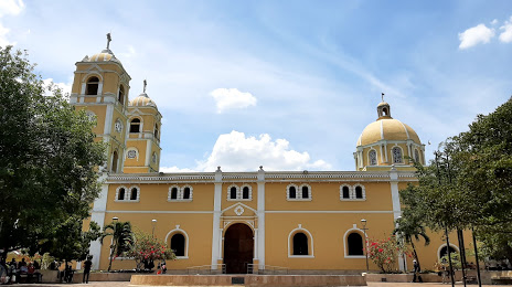
Santander Park (Parque Santander) on the map, Sincelejo, Colombia
Photo
Where is located Santander Park (Parque Santander)
Santander Park (Parque Santander) — local attraction, which is located at Cl. 20 #19-27, Sincelejo, Sucre, Colombia and belongs to the category — park. Average visitor rating for this place — 4.2 (according to 3002 ratings, information from open sources and relevant for 2022).
Exact location — Santander Park (Parque Santander), marked on the map with a red marker.
You can get directions to Santander Park (Parque Santander) on the map from your location.
What else is interesting in Sincelejo? You can see all the sights if you go to the city page.
Coordinates
Santander Park (Parque Santander), Colombia coordinates in decimal format: latitude — 9.32149024254113, longitude — -75.44163796520223. When converted to degrees, minutes, seconds Santander Park (Parque Santander) has the following coordinates: 9°19′17.36 north latitude and -75°26′29.9 east longitude.
Nearby cities
The largest cities that are located nearby:
- Magangué — 71 km
- Monteria — 81 km
- Cartagena — 123 km
- Malambo — 185 km
- Soledad — 191 km
- Barranquilla — 195 km
- Santa Marta — 250 km
- Valledupar — 267 km
- Barrancabermeja — 301 km
- Bello — 329 km
- Medellín — 336 km
- Bucaramanga — 346 km
- Envigado — 347 km
- Giron — 347 km
- Itagüi — 348 km
- Cúcuta — 354 km
- Floridablanca — 355 km
- San Cristobal
 (Venezuela) — 387 km
 - Maicao — 412 km
Distance to the capital
Distance to the capital (Bogota) is about — 547 km.