
 Bel-Ha
San Jose El Alto
El Porvenir
Nueva Palestina
Santa Lucía
Chemax
La Morita
Temoac
Zacualpan
Bel-Ha
San Jose El Alto
El Porvenir
Nueva Palestina
Santa Lucía
Chemax
La Morita
Temoac
Zacualpan
Templo del Carmen on the map, Valle de Santiago, Mexico
Photo
Where is located Templo del Carmen
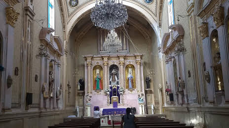
Templo del Carmen — local attraction, which is located at Av. Mena 168, Centro, 38400 Valle de Santiago, Gto., Mexico and belongs to the category — church. Average visitor rating for this place — 4.8 (according to 6 ratings, information from open sources and relevant for 2022).
Exact location — Templo del Carmen, marked on the map with a red marker.
You can get directions to Templo del Carmen on the map from your location.
What else is interesting in Valle de Santiago? You can see all the sights if you go to the city page.
Coordinates
Templo del Carmen, Mexico coordinates in decimal format: latitude — 20.39362900455202, longitude — -101.18159500271143. When converted to degrees, minutes, seconds Templo del Carmen has the following coordinates: 20°23′37.06 north latitude and -101°10′53.74 east longitude.
Nearby cities
The largest cities that are located nearby:
- Salamanca — 19 km
- Irapuato — 36 km
- Celaya — 43 km
- Morelia — 76 km
- Santiago de Querétaro — 86 km
- León — 95 km
- Zamora — 121 km
- San Juan del Río — 126 km
- Uruapan — 140 km
- San Luis Potosi — 196 km
- Aguascalientes — 200 km
- Soledad de Graciano Sánchez — 200 km
- Toluca — 202 km
- Metepec — 209 km
- Tonalá — 213 km
- Cuautitlán Izcalli — 219 km
- Tlaquepaque — 221 km
- Ciudad López Mateos — 221 km
- Guadalajara — 225 km
Distance to the capital
Distance to the capital (Mexico City) is about — 239 km.