
 Bel-Ha
San Jose El Alto
El Porvenir
Nueva Palestina
Santa Lucía
Chemax
La Morita
Temoac
Zacualpan
Bel-Ha
San Jose El Alto
El Porvenir
Nueva Palestina
Santa Lucía
Chemax
La Morita
Temoac
Zacualpan
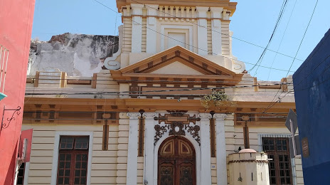
Ex-convento del Carmen on the map, Atlixco, Mexico
Photo
Where is located Ex-convento del Carmen
Ex-convento del Carmen — local attraction, which is located at Calle 4 Nte. 202, Centro, 74200 Atlixco, Pue., Mexico and belongs to the category — museum. Average visitor rating for this place — 4.1 (according to 63 ratings, information from open sources and relevant for 2022).
Exact location — Ex-convento del Carmen, marked on the map with a red marker.
You can get directions to Ex-convento del Carmen on the map from your location.
What else is interesting in Atlixco? You can see all the sights if you go to the city page.
Coordinates
Ex-convento del Carmen, Mexico coordinates in decimal format: latitude — 18.90875003787342, longitude — -98.4328353027349. When converted to degrees, minutes, seconds Ex-convento del Carmen has the following coordinates: 18°54′31.5 north latitude and -98°25′58.21 east longitude.
Nearby cities
The largest cities that are located nearby:
- Puebla — 30 km
- Cuautla — 54 km
- Chalco de Díaz Covarrubias — 62 km
- Ixtapaluca — 63 km
- Jiutepec — 77 km
- Ciudad Nezahualcóyotl — 79 km
- Chimalhuacan — 79 km
- Cuernavaca — 81 km
- Texcoco — 81 km
- Ecatepec — 100 km
- Naucalpan — 104 km
- Tlalnepantla — 104 km
- Ojo de Agua — 105 km
- Coacalco — 106 km
- Buenavista — 108 km
- Ciudad López Mateos — 112 km
- Cuautitlán Izcalli — 118 km
- Tehuacán — 120 km
- Metepec — 126 km
Distance to the capital
Distance to the capital (Mexico City) is about — 94 km.