
 Litoral Del Bajo San Juan
El Cantón de San Pablo
Juan Frío
Santa Barbara
El Juncal
Dibulla
Vereda Campo Alegre
San Pablo
Guaramito
Litoral Del Bajo San Juan
El Cantón de San Pablo
Juan Frío
Santa Barbara
El Juncal
Dibulla
Vereda Campo Alegre
San Pablo
Guaramito
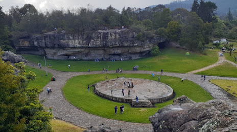
Piedras del Tunjo Archaeological Park on the map, Facatativá, Colombia
Photo
Where is located Piedras del Tunjo Archaeological Park
Piedras del Tunjo Archaeological Park — local attraction, which is located at Cl. 5, Facatativá, Cundinamarca, Colombia and belongs to the category — national park. Average visitor rating for this place — 4.6 (according to 8328 ratings, information from open sources and relevant for 2022).
Exact location — Piedras del Tunjo Archaeological Park, marked on the map with a red marker.
You can get directions to Piedras del Tunjo Archaeological Park on the map from your location.
What else is interesting in Facatativá? You can see all the sights if you go to the city page.
Coordinates
Piedras del Tunjo Archaeological Park, Colombia coordinates in decimal format: latitude — 4.81603914172187, longitude — -74.3462760028706. When converted to degrees, minutes, seconds Piedras del Tunjo Archaeological Park has the following coordinates: 4°48′57.74 north latitude and -74°20′46.59 east longitude.
Nearby cities
The largest cities that are located nearby:
- Soacha — 30 km
- Girardot — 76 km
- Ibagué — 105 km
- Villavicencio — 109 km
- Manizales — 131 km
- Tunja — 137 km
- Dos Quebradas — 145 km
- Pereira — 147 km
- Armenia — 148 km
- Cartago — 172 km
- Sogamoso — 186 km
- Envigado — 203 km
- Itagüi — 204 km
- Medellín — 209 km
- Bello — 214 km
- Tuluá — 218 km
- Neiva — 233 km
- Buga — 237 km
- Barrancabermeja — 254 km
Distance to the capital
Distance to the capital (Bogota) is about — 39 km.