
 Belém
Maranguape
Paranaguá
Paranaguá
Monte Alegre
Alvorada de Minas
Bragança
Laguna
Ibiporã
Belém
Maranguape
Paranaguá
Paranaguá
Monte Alegre
Alvorada de Minas
Bragança
Laguna
Ibiporã
Arajara Park on the map, Barbalha, Brazil
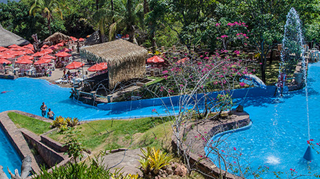
Photo
Where is located Arajara Park
Arajara Park — local attraction, which is located at Sítio Farias e Santo Antônio, s/n Zona Rural - Arajara, Barbalha - CE, 63180-000, Brazil and belongs to the category — water park. Average visitor rating for this place — 4.6 (according to 4050 ratings, information from open sources and relevant for 2022).
Exact location — Arajara Park, marked on the map with a red marker.
You can get directions to Arajara Park on the map from your location.
What else is interesting in Barbalha? You can see all the sights if you go to the city page.
Coordinates
Arajara Park, Brazil coordinates in decimal format: latitude — -7.335753285747434, longitude — -39.4002271434797. When converted to degrees, minutes, seconds Arajara Park has the following coordinates: -7°20′8.71 north latitude and -39°24′0.82 east longitude.
Nearby cities
The largest cities that are located nearby:
- Juazeiro do Norte — 8 km
- Petrolina — 266 km
- Mossoro — 318 km
- Campina Grande — 376 km
- Caruaru — 381 km
- Maracanaú — 387 km
- Arapiraca — 396 km
- Caucaia — 401 km
- Fortaleza — 404 km
- Teresina — 456 km
- Timon — 459 km
- Parnamirim — 469 km
- Maceió — 470 km
- Aracaju — 470 km
- Santa Rita — 476 km
- Camaragibe — 480 km
- Jaboatão dos Guararapes — 481 km
- Natal — 481 km
- João Pessoa — 489 km