
 Belém
Maranguape
Paranaguá
Paranaguá
Monte Alegre
Alvorada de Minas
Bragança
Laguna
Ibiporã
Belém
Maranguape
Paranaguá
Paranaguá
Monte Alegre
Alvorada de Minas
Bragança
Laguna
Ibiporã
Ruínas Igreja Nossa Senhora Conceição on the map, Guarapari, Brazil
Photo
Where is located Ruínas Igreja Nossa Senhora Conceição
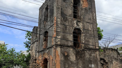
Ruínas Igreja Nossa Senhora Conceição — local attraction, which is located at Centro, Guarapari - State of Espírito Santo, 29200-110, Brazil and belongs to the category — local history museum. Average visitor rating for this place — 4.3 (according to 92 ratings, information from open sources and relevant for 2022).
Exact location — Ruínas Igreja Nossa Senhora Conceição, marked on the map with a red marker.
You can get directions to Ruínas Igreja Nossa Senhora Conceição on the map from your location.
What else is interesting in Guarapari? You can see all the sights if you go to the city page.
Coordinates
Ruínas Igreja Nossa Senhora Conceição, Brazil coordinates in decimal format: latitude — -20.668857627629055, longitude — -40.49505460270685. When converted to degrees, minutes, seconds Ruínas Igreja Nossa Senhora Conceição has the following coordinates: -20°40′7.89 north latitude and -40°29′42.2 east longitude.
Nearby cities
The largest cities that are located nearby:
- Vila Velha — 42 km
- Cariacica — 46 km
- Serra — 64 km
- Cachoeiro de Itapemirim — 67 km
- Colatina — 129 km
- Linhares — 149 km
- Macaé — 230 km
- Valadares Governor — 252 km
- Coronel Fabriciano — 256 km
- Cabo Frio — 290 km
- Araruama — 306 km
- Juiz de Fora — 316 km
- Teresópolis — 318 km
- Teófilo Otoni — 329 km
- Itaboraí — 333 km
- Magé — 339 km
- Petrópolis — 341 km
- Barbacena — 343 km
- São Gonçalo — 353 km